IMAGES TAKEN NEAR TO
Lowcroft Meadow, DONCASTER, DN9 2PY
Introduction
This page details the photographs taken nearby to Lowcroft Meadow, DN9 2PY by members of the Geograph project.
The Geograph project started in 2005 with the aim of publishing, organising and preserving representative images for every square kilometre of Great Britain, Ireland and the Isle of Man.

There are currently over 7.5m images from over14,400 individuals and you can help contribute to the project by visiting https://www.geograph.org.uk
Image Map
Images are licensed for reuse under creativecommons.org/licenses/by-sa/2.0
Notes
- Clicking on the map will re-center to the selected point.
- The higher the marker number, the further away the image location is from the centre of the postcode.
Image Listing (55 Images Found)
Images are licensed for reuse under creativecommons.org/licenses/by-sa/2.0
Image
Details
Distance
1
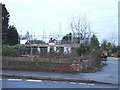
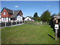
House Restoration
Still a long way to go on this job. It will be nice when it's finished.
Image: © Ian Paterson
Taken: 30 Dec 2007
0.12 miles

3

The former route of the Axholme Joint Railway in Haxey
Construction of the Axholme Joint Railway between Haxey and Goole started in 1899 and opened in August 1903 but the part to Haxey was not opened until 2nd January 1905. For several years, there were two passenger trains and one goods train on weekdays, but extra trains were run on Saturdays and on some Market days. Local farmers used to cart their produce to Haxey Town and Haxey Junction stations and load it into trucks. The goods train brought mail, coal and all the other things that the villagers needed as there was no other way of transporting them. The line began to decline after 1924 with the introduction of bus services in the Isle of Axholme and lorries coming onto the roads to transport goods.
Passenger services ceased on 15th July 1933 and the section from Haxey Junction to Epworth was finally closed completely on 1st February 1956. The land is now managed by North Lincolnshire Council as a footpath and linear nature trail, running from the High Street in Haxey to Epworth. Much of it is in a wooded cutting until it reaches Cliff Hill where it is on an embankment. This is the view further south from High Street.
A much fuller account can be seen at http://www.axholme.info/railway.html and at https://en.wikipedia.org/wiki/Axholme_Joint_Railway More information can be found at https://www.haxeywalkers.co.uk/pictures-of-the-isle-of-axholme-light-railway-near-haxey/
Image: © Marathon
Taken: 8 Sep 2019
0.14 miles
4

Haxey Parish Nature Trail
The Trail runs along the route of a former railway line (closed in 1956), from Haxey to Epworth.
Image: © Tim Heaton
Taken: 23 Oct 2015
0.14 miles
5
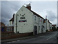
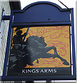
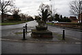
Old Wayside Cross by the A161, Low Street, Haxey
Haxey Cross, old shaft, base & steps, by the A161, in parish of Haxey (North Lincolnshire District), junction with Haxey Lane and High Street, on bend in the A161, by Kings PH, East of the village, on small island in middle of road at junction.
Grade II listed. List Entry Number: 1083255
https://historicengland.org.uk/listing/the-list/list-entry/1083255
Scheduled Monument. List Entry Number: 1015537
https://historicengland.org.uk/listing/the-list/list-entry/1015537
Surveyed
Milestone Society National ID: HMNL_HAX02
Image: © Alan Rosevear
Taken: 13 Jun 2014
0.15 miles
8

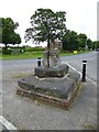
Butter Cross, Low Street, Haxey
Grade II Listed and a Scheduled Ancient Monument the cross occupies its original position and is one of three crosses in Haxey. It is medieval with 20th century refacing to base. It is said to be where farmer's wives would come to sell their butter and it is also associated with the 'Haxey Hood' held on the 6th January each year.
Image: © Jo and Steve Turner
Taken: 31 Jan 2013
0.15 miles
9
The former route of the Axholme Joint Railway in Haxey
Construction of the Axholme Joint Railway between Haxey and Goole started in 1899 and opened in August 1903 but the part to Haxey was not opened until 2nd January 1905. For several years, there were two passenger trains and one goods train on weekdays, but extra trains were run on Saturdays and on some Market days. Local farmers used to cart their produce to Haxey Town and Haxey Junction stations and load it into trucks. The goods train brought mail, coal and all the other things that the villagers needed as there was no other way of transporting them. The line began to decline after 1924 with the introduction of bus services in the Isle of Axholme and lorries coming onto the roads to transport goods.
Passenger services ceased on 15th July 1933 and the section from Haxey Junction to Epworth was finally closed completely on 1st February 1956. The land is now managed by North Lincolnshire Council as a footpath and linear nature trail, running from the High Street in Haxey to Epworth. Much of it is in a wooded cutting until it reaches Cliff Hill where it is on an embankment. This is the view further south from High Street.
A much fuller account can be seen at http://www.axholme.info/railway.html and at https://en.wikipedia.org/wiki/Axholme_Joint_Railway More information can be found at https://www.haxeywalkers.co.uk/pictures-of-the-isle-of-axholme-light-railway-near-haxey/
Image: © Marathon
Taken: 8 Sep 2019
0.15 miles