IMAGES TAKEN NEAR TO
Epworth Road, DONCASTER, DN9 2LL
Introduction
This page details the photographs taken nearby to Epworth Road, DN9 2LL by members of the Geograph project.
The Geograph project started in 2005 with the aim of publishing, organising and preserving representative images for every square kilometre of Great Britain, Ireland and the Isle of Man.

There are currently over 7.5m images from over14,400 individuals and you can help contribute to the project by visiting https://www.geograph.org.uk
Image Map
Images are licensed for reuse under creativecommons.org/licenses/by-sa/2.0
Notes
- Clicking on the map will re-center to the selected point.
- The higher the marker number, the further away the image location is from the centre of the postcode.
Image Listing (16 Images Found)
Images are licensed for reuse under creativecommons.org/licenses/by-sa/2.0
Image
Details
Distance
2
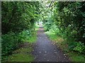
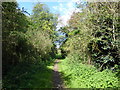
The track bed of the old Axholme Joint Railway
The rails of this relatively short lived railway were finally removed in 1972. See https://en.wikipedia.org/wiki/Axholme_Joint_Railway
Image: © Neil Theasby
Taken: 17 Jun 2020
0.13 miles
4
The Axholme line.
Dismantled railway line near Haxey.
Image: © steven ruffles
Taken: 11 Aug 2014
0.14 miles
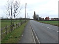
6
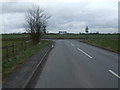
The Nooking (B1396)
Heading north east towards the junction with Epworth Road (A161).
Image: © JThomas
Taken: 28 Feb 2015
0.16 miles
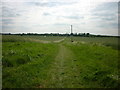
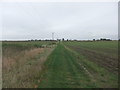
9
The line of the former Axholme Joint Railway
Construction of the Axholme Joint Railway between Haxey and Goole started in 1899 and opened in August 1903 but the part to Haxey was not opened until 2nd January 1905. For several years, there were two passenger trains and one goods train on weekdays, but extra trains were run on Saturdays and on some Market days. Local farmers used to cart their produce to Haxey Town and Haxey Junction stations and load it into trucks. The goods train brought mail, coal and all the other things that the villagers needed as there was no other way of transporting them. The line began to decline after 1924 with the introduction of bus services in the Isle of Axholme and lorries coming onto the roads to transport goods.
Passenger services ceased on 15th July 1933 and the section from Haxey Junction to Epworth was finally closed completely on 1st February 1956. The land is now managed by North Lincolnshire Council as a footpath and linear nature trail, running from the High Street in Haxey to Epworth. Much of it is in a wooded cutting until it reaches Cliff Hill where it is on an embankment. This is just north of The Nooking. Further on the cutting becomes quite deep.
A much fuller account can be seen at http://www.axholme.info/railway.html and at https://en.wikipedia.org/wiki/Axholme_Joint_Railway More information can be found at https://www.haxeywalkers.co.uk/pictures-of-the-isle-of-axholme-light-railway-near-haxey/
Image: © Marathon
Taken: 8 Sep 2019
0.19 miles
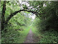
10

The Axeholme trail
The Axeholme trail follows the course of the old railway line towards Epworth. This line shut as long ago as 1956 well before the Beeching cuts of the 1960s.
Image: © roger geach
Taken: 8 Feb 2011
0.19 miles