IMAGES TAKEN NEAR TO
Haxey Carr, DONCASTER, DN9 2JW
Introduction
This page details the photographs taken nearby to DN9 2JW by members of the Geograph project.
The Geograph project started in 2005 with the aim of publishing, organising and preserving representative images for every square kilometre of Great Britain, Ireland and the Isle of Man.

There are currently over 7.5m images from over14,400 individuals and you can help contribute to the project by visiting https://www.geograph.org.uk
Image Map
Images are licensed for reuse under creativecommons.org/licenses/by-sa/2.0
Notes
- Clicking on the map will re-center to the selected point.
- The higher the marker number, the further away the image location is from the centre of the postcode.
Image Listing (25 Images Found)
Images are licensed for reuse under creativecommons.org/licenses/by-sa/2.0
Image
Details
Distance
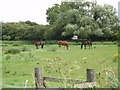
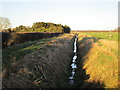
5
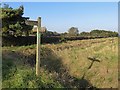
Looking north near Skyers Farm
This is looking along a drainage ditch from Turbary Road, near where it changes from a tarmac road to a dirt track on its way to Haxey Turbary Nature Reserve. It is just beyond Skyers Farm.
Image: © Marathon
Taken: 8 Sep 2019
0.14 miles
6
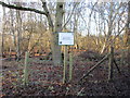
Haxey Turbary Nature Reserve
Haxey Turbary was one of several turbaries on the western edge of the Isle of Axholme. A former bog, it was used for the digging of peat and has now become woodland dominated by birch.
Image: © Jonathan Thacker
Taken: 2 Jan 2017
0.14 miles
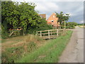
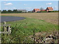
7
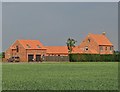
Skyers Farm, Haxey Carr
Confusingly there are two farms with this name in the district. The other Skyers Farm is closer to Epworth.
Image: © Neil Theasby
Taken: 17 Jun 2020
0.15 miles
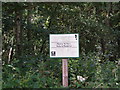
8
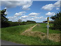
Footpath junction near Haxey Carr
Finger post on Turbary Road - includes plaques associating the paths with the Walking the Way to Health scheme and, commendably, contact details for North Lincolnshire Council's Public Rights of Way section in case of any difficulty using the path.
Image: © Paul Harrop
Taken: 25 Oct 2016
0.15 miles
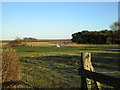
10
Skyers Farm
This view is from the entrance to Summer Croft Farm. It is just beyond Skyers Farm where Turbary Road changes from a tarmac road to a dirt track on its way to Haxey Turbary Nature Reserve.
Image: © Marathon
Taken: 8 Sep 2019
0.16 miles