IMAGES TAKEN NEAR TO
Haxey Carr, DONCASTER, DN9 2FF
Introduction
This page details the photographs taken nearby to DN9 2FF by members of the Geograph project.
The Geograph project started in 2005 with the aim of publishing, organising and preserving representative images for every square kilometre of Great Britain, Ireland and the Isle of Man.

There are currently over 7.5m images from over14,400 individuals and you can help contribute to the project by visiting https://www.geograph.org.uk
Image Map
Images are licensed for reuse under creativecommons.org/licenses/by-sa/2.0
Notes
- Clicking on the map will re-center to the selected point.
- The higher the marker number, the further away the image location is from the centre of the postcode.
Image Listing (5 Images Found)
Images are licensed for reuse under creativecommons.org/licenses/by-sa/2.0
Image
Details
Distance
1
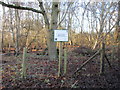
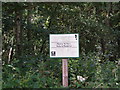
Haxey Turbary Nature Reserve
Haxey Turbary was one of several turbaries on the western edge of the Isle of Axholme. A former bog, it was used for the digging of peat and has now become woodland dominated by birch.
Image: © Jonathan Thacker
Taken: 2 Jan 2017
0.20 miles