IMAGES TAKEN NEAR TO
Westwoodside, DONCASTER, DN9 2BQ
Introduction
This page details the photographs taken nearby to DN9 2BQ by members of the Geograph project.
The Geograph project started in 2005 with the aim of publishing, organising and preserving representative images for every square kilometre of Great Britain, Ireland and the Isle of Man.

There are currently over 7.5m images from over14,400 individuals and you can help contribute to the project by visiting https://www.geograph.org.uk
Image Map
Images are licensed for reuse under creativecommons.org/licenses/by-sa/2.0
Notes
- Clicking on the map will re-center to the selected point.
- The higher the marker number, the further away the image location is from the centre of the postcode.
Image Listing (16 Images Found)
Images are licensed for reuse under creativecommons.org/licenses/by-sa/2.0
Image
Details
Distance
1
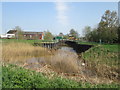
Bullhassocks Pumping Station and South Engine Drain
Image: © John Slater
Taken: 21 Apr 2018
0.01 miles
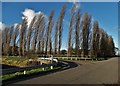
2
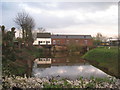
Bullhassocks Pumping Station, near Westwoodside
The pumping station, operated by the Environment Agency, is at the start of the South Engine Drain, and is on the site of a steam powered station which was later upgraded to a diesel pump, then to two electric pumps enabling it to discharge 330 tons of water per minute. It was originally designed to handle water from the South Idle drains, but prior to 1970 also had to pump water from the Folly Drain.
Image: © Paul Harrop
Taken: 25 Oct 2016
0.01 miles
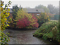
3
Bull Hassock Pumping Station
This is a critical pumping station for a large area between Haxey, Wroot and Epworth. The geese (just visible) make sure there are no unauthorised visitors.
Image: © Jonathan Thacker
Taken: 3 Apr 2011
0.02 miles
6
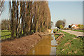
South Idle Drain
Drain beside Idle Bank with a fallen poplar from Thorn Cottage Farm
Image: © Richard Croft
Taken: 28 Mar 2012
0.06 miles
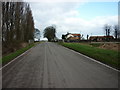
7
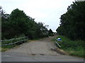
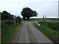
Track to Greenholme Bank Farm
Bridges Folly Drain.
Image: © JThomas
Taken: 28 Jun 2014
0.08 miles
9
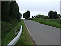
Junction of Thorn Bank with Idle Bank
Looking east.
Image: © JThomas
Taken: 28 Jun 2014
0.09 miles
10
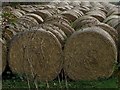
Bales near Wroot
Straw bales lined up to the east of Idle Bank, next to Greenholme Bank Farm
Image: © Paul Harrop
Taken: 25 Oct 2016
0.10 miles