IMAGES TAKEN NEAR TO
Shires Close, DONCASTER, DN9 1BN
Introduction
This page details the photographs taken nearby to Shires Close, DN9 1BN by members of the Geograph project.
The Geograph project started in 2005 with the aim of publishing, organising and preserving representative images for every square kilometre of Great Britain, Ireland and the Isle of Man.

There are currently over 7.5m images from over14,400 individuals and you can help contribute to the project by visiting https://www.geograph.org.uk
Image Map
Images are licensed for reuse under creativecommons.org/licenses/by-sa/2.0
Notes
- Clicking on the map will re-center to the selected point.
- The higher the marker number, the further away the image location is from the centre of the postcode.
Image Listing (99 Images Found)
Images are licensed for reuse under creativecommons.org/licenses/by-sa/2.0
Image
Details
Distance
1
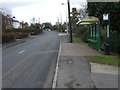
Bus stop and shelter on Burnham Road, Epworth
Looking south.
Image: © JThomas
Taken: 28 Feb 2015
0.05 miles
4
Yet another chapel in Epworth
You could easily miss this tiny former chapel in Chapel Street.
Image: © Chris
Taken: 4 Aug 2013
0.07 miles
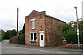
6
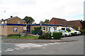
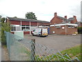
Epworth Telephone Exchange (1)
Located at 26A Burnham Road (A161), this building would appear to date from the 1960s replacing a smaller TE in the same village. It has the code SLEP, and provides telephone and broadband services to 2,931 residential and 197 non-residential premises in Epworth and the surrounding area including Belton. The blue building behind the TE to the left of the photo is that of South Axholme Academy, a secondary school.
Image: © David Hillas
Taken: 18 Jul 2019
0.08 miles
7
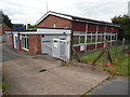
Epworth Telephone Exchange (2)
This photo shows the back of the TE with an Openreach van parked by the blue door and a pale green generator to the left. Its numbering range is (01427) 87xxxx, (the 01427) referring to the Gainsborough group of twelve TEs, and its postcode is DN9 1BY.
Image: © David Hillas
Taken: 18 Jul 2019
0.09 miles
8
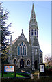
Wesley Memorial Church
Situated on the High Street and of 1888-9 by Charles Bell of Grimsby. Rock-faced with ashlar dressings. Very Anglican in appearance for a Methodist church.
Image: © David Wright
Taken: 9 Dec 2006
0.11 miles
9
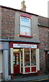
Sweeney's Gentlemens Barbers
Sweeney's Gentlemens Barbers shop on High Street.
Image: © David Wright
Taken: 9 Dec 2006
0.11 miles
10
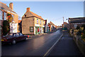
Epworth High Street
Photo taken near the Methodist memorial church looking towards Market Place.
Image: © David Wright
Taken: 9 Dec 2006
0.11 miles