IMAGES TAKEN NEAR TO
Epworth, DONCASTER, DN9 1AD
Introduction
This page details the photographs taken nearby to DN9 1AD by members of the Geograph project.
The Geograph project started in 2005 with the aim of publishing, organising and preserving representative images for every square kilometre of Great Britain, Ireland and the Isle of Man.

There are currently over 7.5m images from over14,400 individuals and you can help contribute to the project by visiting https://www.geograph.org.uk
Image Map
Images are licensed for reuse under creativecommons.org/licenses/by-sa/2.0
Notes
- Clicking on the map will re-center to the selected point.
- The higher the marker number, the further away the image location is from the centre of the postcode.
Image Listing (23 Images Found)
Images are licensed for reuse under creativecommons.org/licenses/by-sa/2.0
Image
Details
Distance
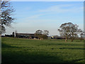
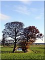
4
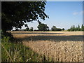
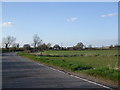
Near Low Melwood Farm
Almost time for harvest.
Image: © Jonathan Thacker
Taken: 30 Jul 2011
0.05 miles
5
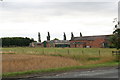
Low Melwood Farm
This stands on the site of one of only 9 Carthusian priories established in Britain. A few fragments exist incorporated into the remains of what was probably the house built after the dissolution in 1539. The site, covering the immediate surroundings of the farmyard is a scheduled monument.
Image: © Alan Murray-Rust
Taken: 13 Mar 2011
0.05 miles
6
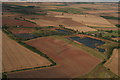
High and Low Melwood: aerial
This is a picture of both High Melwood House and Low Melwood Farm, showing the old claypits and also the site which is marked as the remains of a Carthusian priory.
The latter seems to extend over the arable field, with the pylon in the middle, to the right hand pond.
The site and scant remains of a Carthusian priory and old claypits. The priory is one of the ten medieval Carthusian houses (charterhouses) in England. It was established in 1397/1398 by Thomas Mowbray, Earl of Nottingham and later Duke of Norfolk. The house was centred on a pre-existing chapel on the present Low Melwood Farm, between Owston Ferry and Epworth in the Isle of Axholme, which according to a papal bull of 1398, was called anciently, "the Priory of the Wood." The full name of the monastery was The House of the Visitation of the Blessed Virgin Mary.
The prior, Saint Augustine Webster, was imprisoned in the Tower of London in 1535 for refusing the Oath of Supremacy and later martyred and canonised. The monastery was suppressed during the Dissolution of the Monasteries in June 1538. Afterwards the buildings were converted by John Candysshe into a house: parts still survive as do some earthworks. There has been limited excavation.
With thanks to Dave Hitchborne for the historical information.
Image: © Chris
Taken: 2 Sep 2012
0.09 miles
7
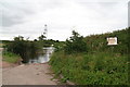
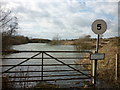
Deep water? You ain't kidding!
Still a working quarry, opposite Low Melwood Farm
Image: © Chris
Taken: 4 Aug 2013
0.09 miles
8
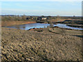
Former quarry at Low Melwood
The origins of this are marked as clay pit.
Image: © Alan Murray-Rust
Taken: 13 Mar 2011
0.11 miles
9
Remains of a moated priory at Low Melwood Farm
The site of Axholme Priory, a Carthusian monastery founded in 1395
Image: © Graham Hogg
Taken: 28 Nov 2017
0.12 miles
