High and Low Melwood: aerial
Introduction
The photograph on this page of High and Low Melwood: aerial by Chris as part of the Geograph project.
The Geograph project started in 2005 with the aim of publishing, organising and preserving representative images for every square kilometre of Great Britain, Ireland and the Isle of Man.

There are currently over 7.5m images from over 14,400 individuals and you can help contribute to the project by visiting https://www.geograph.org.uk
High and Low Melwood: aerial
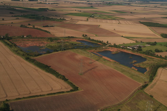
Image: © Chris Taken: 2 Sep 2012
This is a picture of both High Melwood House and Low Melwood Farm, showing the old claypits and also the site which is marked as the remains of a Carthusian priory. The latter seems to extend over the arable field, with the pylon in the middle, to the right hand pond. The site and scant remains of a Carthusian priory and old claypits. The priory is one of the ten medieval Carthusian houses (charterhouses) in England. It was established in 1397/1398 by Thomas Mowbray, Earl of Nottingham and later Duke of Norfolk. The house was centred on a pre-existing chapel on the present Low Melwood Farm, between Owston Ferry and Epworth in the Isle of Axholme, which according to a papal bull of 1398, was called anciently, "the Priory of the Wood." The full name of the monastery was The House of the Visitation of the Blessed Virgin Mary. The prior, Saint Augustine Webster, was imprisoned in the Tower of London in 1535 for refusing the Oath of Supremacy and later martyred and canonised. The monastery was suppressed during the Dissolution of the Monasteries in June 1538. Afterwards the buildings were converted by John Candysshe into a house: parts still survive as do some earthworks. There has been limited excavation. With thanks to Dave Hitchborne for the historical information.
Images are licensed for reuse under creativecommons.org/licenses/by-sa/2.0
Image Location
Latitude
53.508202
Longitude
-0.790376