IMAGES TAKEN NEAR TO
Epworth, DONCASTER, DN9 1AB
Introduction
This page details the photographs taken nearby to DN9 1AB by members of the Geograph project.
The Geograph project started in 2005 with the aim of publishing, organising and preserving representative images for every square kilometre of Great Britain, Ireland and the Isle of Man.

There are currently over 7.5m images from over14,400 individuals and you can help contribute to the project by visiting https://www.geograph.org.uk
Image Map
Images are licensed for reuse under creativecommons.org/licenses/by-sa/2.0
Notes
- Clicking on the map will re-center to the selected point.
- The higher the marker number, the further away the image location is from the centre of the postcode.
Image Listing (12 Images Found)
Images are licensed for reuse under creativecommons.org/licenses/by-sa/2.0
Image
Details
Distance
3
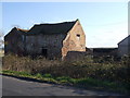
Honesty shop at High Melwood
Sold jam and chutney to the geographers
Image: © Graham Hogg
Taken: 28 Nov 2017
0.06 miles
5
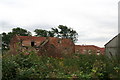
High Melwood Farm
Seen from the higher ground above, and looking beyond to Owston Ferry. The farmhouse dates from probably the early 18th century with later 18/19th century additions. Listed Grade II.
Image: © Alan Murray-Rust
Taken: 13 Mar 2011
0.10 miles
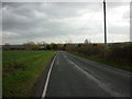
7
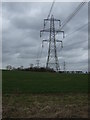
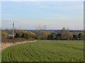
Crop field and pylons
Near High Melwood House.
Image: © JThomas
Taken: 28 Feb 2015
0.22 miles
9
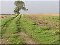
Trees on a Hill
These trees give an indication as to the prevailing wind direction.
Image: © Michael Patterson
Taken: 30 Oct 2006
0.24 miles
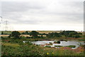
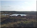
10
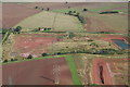
High Melwood clay pits, aerial
Disused clay pits at High Melwood Farm. The "clay" is Mercia Mudstone - see http://www.glnp.org.uk/admin/resources/lgap-2016-final-2.pdf
It is marked on the map that the two fields in front of the pits contain the remains of a Carthusian Priory.
Image: © Chris
Taken: 3 Sep 2006
0.24 miles