IMAGES TAKEN NEAR TO
Oldfield Close, DONCASTER, DN7 5NP
Introduction
This page details the photographs taken nearby to Oldfield Close, DN7 5NP by members of the Geograph project.
The Geograph project started in 2005 with the aim of publishing, organising and preserving representative images for every square kilometre of Great Britain, Ireland and the Isle of Man.

There are currently over 7.5m images from over14,400 individuals and you can help contribute to the project by visiting https://www.geograph.org.uk
Image Map
Images are licensed for reuse under creativecommons.org/licenses/by-sa/2.0
Notes
- Clicking on the map will re-center to the selected point.
- The higher the marker number, the further away the image location is from the centre of the postcode.
Image Listing (7 Images Found)
Images are licensed for reuse under creativecommons.org/licenses/by-sa/2.0
Image
Details
Distance
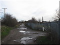

3

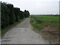
Track through the allotments
Pictured from Oldfield Lane, Staniforth - through a locked security gate.
Image: © Neil Theasby
Taken: 13 Jan 2022
0.14 miles
4
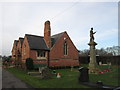
Cemetery chapel and war memorial, Stainforth
Image: © John Slater
Taken: 6 Feb 2014
0.17 miles
5
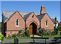
Stainforth - Cemetery chapel
For an alternative view, please see Image
Image: © Dave Bevis
Taken: 6 Jun 2014
0.17 miles
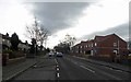
7
Footpath and Topped Trees
The trees by the side of this footpath to Stainfortth have had their tops removed.
Image: © Michael Patterson
Taken: 16 Oct 2006
0.24 miles