IMAGES TAKEN NEAR TO
St. Marys Road, DONCASTER, DN7 4DQ
Introduction
This page details the photographs taken nearby to St. Marys Road, DN7 4DQ by members of the Geograph project.
The Geograph project started in 2005 with the aim of publishing, organising and preserving representative images for every square kilometre of Great Britain, Ireland and the Isle of Man.

There are currently over 7.5m images from over14,400 individuals and you can help contribute to the project by visiting https://www.geograph.org.uk
Image Map
Images are licensed for reuse under creativecommons.org/licenses/by-sa/2.0
Notes
- Clicking on the map will re-center to the selected point.
- The higher the marker number, the further away the image location is from the centre of the postcode.
Image Listing (10 Images Found)
Images are licensed for reuse under creativecommons.org/licenses/by-sa/2.0
Image
Details
Distance

2
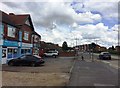
Shops and Houses on High Street in Dunsville
Image: © Jonathan Clitheroe
Taken: 22 Jul 2017
0.07 miles
3
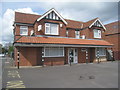
Dunsville Medical Centre
Occupies a pair of former semi-detached houses. This is one of two styles of housing to be found in the older parts of Dunsville.
Image: © Jonathan Thacker
Taken: 26 Apr 2014
0.09 miles
4
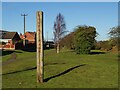
The entrance to Quarry Park
This former quarrying site is now a park and local nature reserve.
Image: © Graham Hogg
Taken: 20 Jan 2023
0.11 miles
5
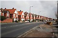
St. James Avenue, Dunsville
The older housing in Dunsville come in two styles. Semi-detached under one gable or semi-detached with two gables. Here in St. James Avenue the two styes face each other across the road.
Image: © Jonathan Thacker
Taken: 26 Apr 2014
0.13 miles
8
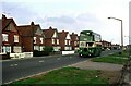
High Street, Dunsville
Housing developed for workers at Hatfield Main Colliery in the late 1930s. The bus belongs the Severns of Dunscroft, one of a number of small bus operators in the area serving the various colliery villages. Not much changed in the next 30 years https://www.geograph.org.uk/photo/372142 .
This is one of a series of views featuring buses in the 60s, 70s, and 80s. http://www.geograph.org.uk/search.php?i=137652761
Image: © Alan Murray-Rust
Taken: 27 Sep 1976
0.16 miles
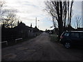
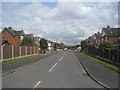
10
High Street, Dunsville
Houses on the A18 heading towards Thorne
Image: © Richard Croft
Taken: 20 Mar 2007
0.22 miles