IMAGES TAKEN NEAR TO
Doncaster Road, DONCASTER, DN5 7SU
Introduction
This page details the photographs taken nearby to Doncaster Road, DN5 7SU by members of the Geograph project.
The Geograph project started in 2005 with the aim of publishing, organising and preserving representative images for every square kilometre of Great Britain, Ireland and the Isle of Man.

There are currently over 7.5m images from over14,400 individuals and you can help contribute to the project by visiting https://www.geograph.org.uk
Image Map
Images are licensed for reuse under creativecommons.org/licenses/by-sa/2.0
Notes
- Clicking on the map will re-center to the selected point.
- The higher the marker number, the further away the image location is from the centre of the postcode.
Image Listing (45 Images Found)
Images are licensed for reuse under creativecommons.org/licenses/by-sa/2.0
Image
Details
Distance
1
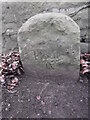
Old milestone, Doncaster Road, High Melton
At the east end of High Melton on the unclassified road between Sprotbrough and Barnburgh. For 40 years it was seen with only the top few inches showing. After roadworks it was reset although it is broken just below present ground level. Part of the legend 'From/Wentworth' has eroded away Houſe also has its e missing. From the 1720s Thomas Watson-Wentworth, later 1st Marquis of Rockingham, had miles marked on the various routes from Wentworth, sometimes on trees, building or convenient stones. From 1750 he had stones set up. This one is on his route to the Great North Road north of Doncaster.
Image: © Chris Minto
Taken: 5 Jan 2019
0.04 miles
2
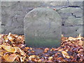
Milestone in High Melton
Difficult to read but Old-Maps.co.uk shows this to be Wentworth House 9 Miles
Image: © John Slater
Taken: 30 Oct 2012
0.04 miles
3
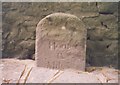
Old Milestone by Doncaster Road, High Melton
Milestone by the UC road, in parish of High Melton (Doncaster District), Doncaster Road, at East end of High Melton village, just North of Leylands Farm Cottages, back to wall in front of first pair of semi-detached houses.
Inscription reads:-
(Wentworth)
Houfe
IX
Miles
Grade II listed.
List Entry Number: 1151624 https://historicengland.org.uk/listing/the-list/list-entry/1151624
Milestone Society National ID: YS_WWH09
Image: © Milestone Society
Taken: Unknown
0.04 miles
5
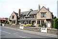
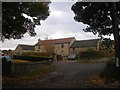
Estate Cottages
An attractive row of four grade II listed cottages in the Arts & Crafts style on Doncaster Road at High Melton. Reputedly by 'Mr.Johnson' of Doncaster for Frederick Montague of Melton Hall and the two end doorways have datestones of FJOM 1904
Image: © Richard Croft
Taken: 15 Aug 2008
0.08 miles
6
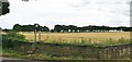
Footpath through the grain
But not beyond the line of trees
Image: © Chris Morgan
Taken: 20 Jul 2020
0.08 miles
7

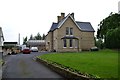
Footpath to Cadeby Lane
Footpath from High Melton to Cadeby
Image: © Richard Croft
Taken: 15 Aug 2008
0.10 miles
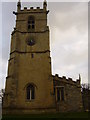
9
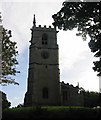
St James' Church High Melton
The ground plan is rather unusual, having two aisles - open through a short nave within the chancel and the Western Tower, and also a continuous south aisle to the whole length of the church.
Image: © David Rogers
Taken: 10 Oct 2003
0.12 miles
10
High Melton church
Nice gargoyles on St James' church.
Image: © steven ruffles
Taken: 12 Dec 2009
0.12 miles