IMAGES TAKEN NEAR TO
Grove Court, DONCASTER, DN5 7AL
Introduction
This page details the photographs taken nearby to Grove Court, DN5 7AL by members of the Geograph project.
The Geograph project started in 2005 with the aim of publishing, organising and preserving representative images for every square kilometre of Great Britain, Ireland and the Isle of Man.

There are currently over 7.5m images from over14,400 individuals and you can help contribute to the project by visiting https://www.geograph.org.uk
Image Map
Images are licensed for reuse under creativecommons.org/licenses/by-sa/2.0
Notes
- Clicking on the map will re-center to the selected point.
- The higher the marker number, the further away the image location is from the centre of the postcode.
Image Listing (28 Images Found)
Images are licensed for reuse under creativecommons.org/licenses/by-sa/2.0
Image
Details
Distance
1
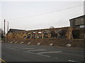
Partly demolished farm building at Manor Farm
This was a listed building http://www.britishlistedbuildings.co.uk/en-334554-shelter-shed-approximately-40-metres-to-#.Vuan2Eeq-Tw
Image: © Jonathan Thacker
Taken: 13 Mar 2016
0.04 miles
2
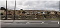
Remains of colonnade at Manor Farm, Marr
Currently awaiting redevelopment.
Only 4 years ago it looked like this; https://www.geograph.org.uk/photo/5106900
Image: © Chris Morgan
Taken: 20 Jul 2020
0.05 miles
3
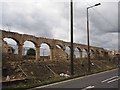
Partially demolished stone arches
At Manor Farm on a site which is being developed for residential use. The arches were part of an arcade used for storage of farm equipment. They date from the early 19th century and are grade II listed so it is surprising to see them in this condition. In 2016 they looked like this Image
Image: © Graham Hogg
Taken: 20 Jul 2020
0.05 miles
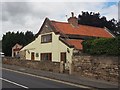
4
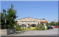
Marr Lodge.
Restaurant and family pub.
Image: © Steve Fareham
Taken: 24 Aug 2007
0.05 miles
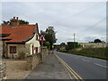
6
School Cottage
On the very busy A635 Barnsley Road in Marr
Image: © Graham Hogg
Taken: 20 Jul 2020
0.07 miles
7
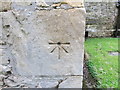
Ordnance Survey Cut Mark with Bolt
This can be found on the wall of St Helen's Church, Marr.
For more detail see : http://www.bench-marks.org.uk/bm29485
Image: © Peter Wood
Taken: 4 Jun 2014
0.08 miles
8
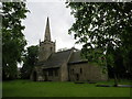
The Church of St Helen at Marr
Viewed from the south-west.
Image: © Peter Wood
Taken: 4 Jun 2014
0.08 miles
9
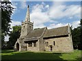
Church of St Helen in Marr
Grade I listed.See http://www.britishlistedbuildings.co.uk/en-334555-church-of-st-helen-marr-#.Vaf6rvlViko
Image: © Neil Theasby
Taken: 16 Jul 2015
0.08 miles
10
Church of St Helen
Grade I listed parish church dating from the 12th century
Image: © Graham Hogg
Taken: 20 Jul 2020
0.08 miles