IMAGES TAKEN NEAR TO
Suggitts Court, CLEETHORPES, DN35 7JW
Introduction
This page details the photographs taken nearby to Suggitts Court, DN35 7JW by members of the Geograph project.
The Geograph project started in 2005 with the aim of publishing, organising and preserving representative images for every square kilometre of Great Britain, Ireland and the Isle of Man.

There are currently over 7.5m images from over14,400 individuals and you can help contribute to the project by visiting https://www.geograph.org.uk
Image Map
Images are licensed for reuse under creativecommons.org/licenses/by-sa/2.0
Notes
- Clicking on the map will re-center to the selected point.
- The higher the marker number, the further away the image location is from the centre of the postcode.
Image Listing (66 Images Found)
Images are licensed for reuse under creativecommons.org/licenses/by-sa/2.0
Image
Details
Distance
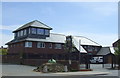
1

Site of The Leaking Boot
Cleared site of The Leaking Boot http://www.geograph.org.uk/photo/1069960 on Grimsby Road
Image: © Richard Croft
Taken: 20 Oct 2010
0.08 miles
3

Site of The Leaking Boot
Site of The Leaking Boot http://www.geograph.org.uk/photo/1069966 on Grimsby Road
Image: © Richard Croft
Taken: 20 Oct 2010
0.08 miles
4

The sign of The Leaking Boot
Sign for The Leaking Boot http://www.geograph.org.uk/photo/1069960 on Grimsby Road, Cleethorpes
Image: © Richard Croft
Taken: 5 Dec 2008
0.08 miles
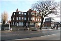
5
The Leaking Boot
Large pub on Grimsby Road, now closed
Image: © Richard Croft
Taken: 5 Dec 2008
0.08 miles
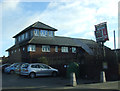
6
The Leaking Boot
Closed pub on Grimsby Road
Image: © Richard Croft
Taken: 5 Dec 2008
0.08 miles
8
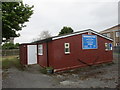
Christadelphian Church, Suggitt's Lane
For a description of Christadelphianism see https://en.wikipedia.org/wiki/Christadelphians
Image: © Jonathan Thacker
Taken: 13 May 2016
0.09 miles
9
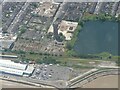
Water Tower and Chapman's Pond, Cleethorpes: aerial 2024
Image: © Simon Tomson
Taken: 16 Jun 2024
0.10 miles
10
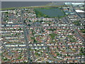
Cleethorpes 2007 (aerial): 3
The water tower is top right next to the "Fish Pond". Running right left are:
- the railway line (on the shoreline);
- Grimsby Road (this side of the pond); and
- Brereton Avenue (closest to the camera).
Image: © John Hardy
Taken: 8 Aug 2007
0.10 miles