IMAGES TAKEN NEAR TO
Pelham Road, CLEETHORPES, DN35 7JT
Introduction
This page details the photographs taken nearby to Pelham Road, DN35 7JT by members of the Geograph project.
The Geograph project started in 2005 with the aim of publishing, organising and preserving representative images for every square kilometre of Great Britain, Ireland and the Isle of Man.

There are currently over 7.5m images from over14,400 individuals and you can help contribute to the project by visiting https://www.geograph.org.uk
Image Map (Loading...)


Getting Data...Please wait
Leaflet Map data © OpenStreetMap
Images are licensed for reuse under creativecommons.org/licenses/by-sa/2.0
Notes
- Clicking on the map will re-center to the selected point.
- The higher the marker number, the further away the image location is from the centre of the postcode.
Image Listing (68 Images Found)
Images are licensed for reuse under creativecommons.org/licenses/by-sa/2.0
Image
Details
Distance
1

Pelham Road and the background the water tower
Image: © Steve Fareham
Taken: 12 Oct 2015
0.03 miles
2
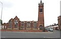
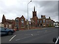
Beaconthorpe Methodist Church 2024, after the fire (3)
Arts and Crafts Gothic style.
See https://www.heritagegateway.org.uk/Gateway/Results_Single.aspx?uid=MNL461&resourceID=1039 and
Image
Received Planning Permission for conversion to flats, but suffered an arson attack in October 2023.
Image: © Chris
Taken: 24 Apr 2024
0.08 miles
3
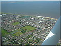
Cleethorpes 2007 (aerial): 4
Clee Road runs diagonally from the bottom left corner, past the playing field, to Isaac's Hill roundabout (by the white art deco former Electricity Board building).
The water tower is in the middle near the shoreline, with Blundell Park football ground top left.
Image: © John Hardy
Taken: 8 Aug 2007
0.08 miles
4
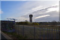
Water tower at Cleethorpes.
A walk along the prom.
Image: © steven ruffles
Taken: 9 Nov 2019
0.08 miles
5
Beaconthorpe Methodist Church 2024, after the fire (2)
Arts and Crafts Gothic style.
See https://www.heritagegateway.org.uk/Gateway/Results_Single.aspx?uid=MNL461&resourceID=1039 and
Image
Received Planning Permission for conversion to flats, but suffered an arson attack in October 2023.
Image: © Chris
Taken: 24 Apr 2024
0.08 miles
6
Beaconthorpe Methodist Church 2024, after the fire (1)
Arts and Crafts Gothic style.
See https://www.heritagegateway.org.uk/Gateway/Results_Single.aspx?uid=MNL461&resourceID=1039 and
Image
Received Planning Permission for conversion to flats, but suffered an arson attack in October 2023.
Image: © Chris
Taken: 24 Apr 2024
0.08 miles
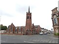
7
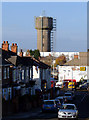
Cleethorpes Water Tower
Photo taken from Grant Street near junction with Prince's Road.
Image: © David Wright
Taken: 18 Nov 2006
0.09 miles
8
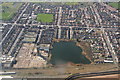
Chapman's Pond and the Water Tower, Cleethorpes: aerial 2015
Image: © Chris
Taken: 25 Mar 2015
0.09 miles
9

Grimsby and west: aerial 2015
Humber Gateway Windfarm on the horizon: see Image
Image: © Chris
Taken: 9 Aug 2015
0.10 miles
10
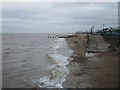
The beach, Cleethorpes
Near high tide.
Image: © Jonathan Thacker
Taken: 13 May 2016
0.10 miles