IMAGES TAKEN NEAR TO
Yarborough Road, GRIMSBY, DN34 4ES
Introduction
This page details the photographs taken nearby to Yarborough Road, DN34 4ES by members of the Geograph project.
The Geograph project started in 2005 with the aim of publishing, organising and preserving representative images for every square kilometre of Great Britain, Ireland and the Isle of Man.

There are currently over 7.5m images from over14,400 individuals and you can help contribute to the project by visiting https://www.geograph.org.uk
Image Map (Loading...)


Getting Data...Please wait
Leaflet Map data © OpenStreetMap
Images are licensed for reuse under creativecommons.org/licenses/by-sa/2.0
Notes
- Clicking on the map will re-center to the selected point.
- The higher the marker number, the further away the image location is from the centre of the postcode.
Image Listing (15 Images Found)
Images are licensed for reuse under creativecommons.org/licenses/by-sa/2.0
Image
Details
Distance
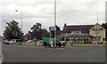
6
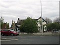
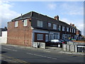
Public House sheltering from the roundabout
As we are in a fishing port aptly named, The Trawl.
Image: © Martin Dawes
Taken: 29 Apr 2017
0.10 miles
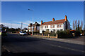
7
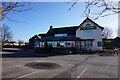
The Trawl public house on Yarborough Road, Grimsby
Image: © Ian S
Taken: 11 Mar 2020
0.10 miles