IMAGES TAKEN NEAR TO
Albert Street West, GRIMSBY, DN32 7SL
Introduction
This page details the photographs taken nearby to Albert Street West, DN32 7SL by members of the Geograph project.
The Geograph project started in 2005 with the aim of publishing, organising and preserving representative images for every square kilometre of Great Britain, Ireland and the Isle of Man.

There are currently over 7.5m images from over14,400 individuals and you can help contribute to the project by visiting https://www.geograph.org.uk
Image Map
Images are licensed for reuse under creativecommons.org/licenses/by-sa/2.0
Notes
- Clicking on the map will re-center to the selected point.
- The higher the marker number, the further away the image location is from the centre of the postcode.
Image Listing (148 Images Found)
Images are licensed for reuse under creativecommons.org/licenses/by-sa/2.0
Image
Details
Distance
1
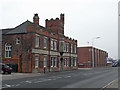
Victoria Street North, Grimsby
The crenellated building was originally a barracks. The modern block beyond is a branch of Curry's.
Image: © David Wright
Taken: 18 Feb 2010
0.02 miles
2
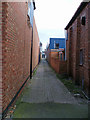
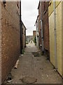
Ten Foot, Railway Street
This cobbled alley runs East from Railway Street towards Freeman Street.
Image: © David Wright
Taken: 17 Mar 2007
0.02 miles
3
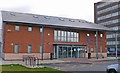
The Blue Cross Animal Hospital, Grimsby
After more than 40 years of providing vital services, this hospital has now moved from the old site on Cleethorpe Road, to Nelson Street. Unveiled in July 2005, the new building includes three operating theatres, four treatment clinics, new kenneling areas, access for disabled clients and much needed new equipment to handle the thousands of treatments delivered each year.
Address: Coco Markus House, Nelson Street, Grimsby, NE Lincs, DN32 7SH
Image: © David Wright
Taken: 17 Mar 2007
0.04 miles
4
Guru Nanak Sikh Temple
This temple is situated on Railway Street.
Image: © David Wright
Taken: 17 Mar 2007
0.04 miles
5
Ten Foot, Freeman Street
This cobbled alley runs between Freeman Street and Railway Street.
Image: © David Wright
Taken: 22 Aug 2007
0.05 miles
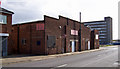
6
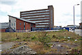
Railway Street, Grimsby
Photo taken from a vacant site on the corner of Albert Street West. The nearest building is the Blue Cross Veterinary Centre and behind looms the undistinguished bulk of a 1960's concrete block on Nelson Street occupied by the Benefits Agency.
Image: © David Wright
Taken: 6 Apr 2007
0.05 miles
7
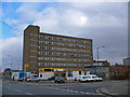
IBWEST Security, Railway Street, Grimsby
IBWEST is on the corner site in the foreground. I don't know the function of the unattractive block in the background but it has all the attributes of 1960's Government offices.
Image: © David Wright
Taken: 17 Mar 2007
0.05 miles
8
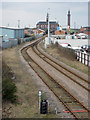
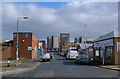
The Line to Grimsby Docks
Photo taken from the footbridge between King Edward Street and Railway Street.
Image: © David Wright
Taken: 17 Mar 2010
0.06 miles
9
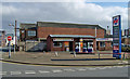
Railway Street Filling Station, Grimsby
Unleaded at 96.9p, Diesel 97.9p.
Image: © David Wright
Taken: 17 Mar 2007
0.06 miles
10
Church Street, Grimsby
Photo taken from Railway Street looking towards Freeman Street.
Image: © David Wright
Taken: 17 Mar 2007
0.06 miles