IMAGES TAKEN NEAR TO
Gilbey Road, GRIMSBY, DN31 2SL
Introduction
This page details the photographs taken nearby to Gilbey Road, DN31 2SL by members of the Geograph project.
The Geograph project started in 2005 with the aim of publishing, organising and preserving representative images for every square kilometre of Great Britain, Ireland and the Isle of Man.

There are currently over 7.5m images from over14,400 individuals and you can help contribute to the project by visiting https://www.geograph.org.uk
Image Map (Loading...)


Getting Data...Please wait
Leaflet Map data © OpenStreetMap
Images are licensed for reuse under creativecommons.org/licenses/by-sa/2.0
Notes
- Clicking on the map will re-center to the selected point.
- The higher the marker number, the further away the image location is from the centre of the postcode.
Image Listing (27 Images Found)
Images are licensed for reuse under creativecommons.org/licenses/by-sa/2.0
Image
Details
Distance
1
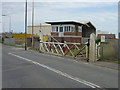
Pyewipe Road Level Crossing, Gilbey Road
The name of the crossing is a bit confusing, as the road is certainly Gilbey Road. A fine surviving example of traditional wooden gates, and an interesting modern(ish) signal box. There does still appear to be a small amount of traffic on the railway.
Image: © Alan Murray-Rust
Taken: 13 Jul 2008
0.06 miles

4
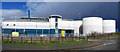
Pyewipe Waste Water Treatment Works
Anglian Water Pyewipe Waste Water Treatment Works. Picture taken from the adjacent road looking approx. northwest. This is a composite image from two original photos as the plant is very large and even with a 28mm lens I could not get it all in one shot. Taken on a showery April afternoon.
Image: © David Wright
Taken: 2 Apr 2006
0.14 miles
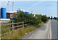
5
Abandoned carpark
In the two years since Alan Murray-Rust's photograph ( http://www.geograph.org.uk/photo/882803 ) the state of the carpark has deteriorated even further and is now inaccessible and unuseable.
Image: © Jonathan Thacker
Taken: 25 Sep 2010
0.15 miles
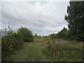
6
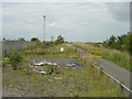
Derelict car park
The notice states that this car park has been provided for the use of - among others - birdwatchers using the hide http://www.geograph.org.uk/photo/882790. The sign at the end of the footpath http://www.geograph.org.uk/photo/369243 has deteriorated significantly too.
Image: © Alan Murray-Rust
Taken: 13 Jul 2008
0.15 miles
7
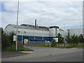
Pyewipe Waste Water Treatment Works
Although this is the normal modern term for what used to be called a sewage works, in this case a large amount of the effluent doubtlessly comes from the various chemical industries.
Image: © Alan Murray-Rust
Taken: 13 Jul 2008
0.16 miles
8
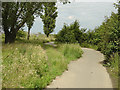
Path to the foreshore
Although clearly constructed specifically to give access to the sea wall path, this is not apparently designated as a right of way.
Image: © Alan Murray-Rust
Taken: 13 Jul 2008
0.17 miles
9
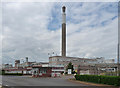
Factory, Grimsby (1)
A vast plant with a soaring chimney. Sadly, it closed in 2009, with the loss of more than 200 jobs, a fact which I hadn't realised when I took the photo. It was operated by Huntsman Tioxide for the production of titanium dioxide, used as a whitening pigment in, amongst other things, coatings, plastics, inks, cosmetics and food.
Image: © Stephen Richards
Taken: 15 Jun 2011
0.17 miles
10
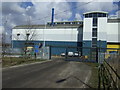
Entrance to Pyewipe Waste Water Treatment Plant
Image: © JThomas
Taken: 30 Mar 2013
0.17 miles