IMAGES TAKEN NEAR TO
Leverton Road, RETFORD, DN22 6QG
Introduction
This page details the photographs taken nearby to Leverton Road, DN22 6QG by members of the Geograph project.
The Geograph project started in 2005 with the aim of publishing, organising and preserving representative images for every square kilometre of Great Britain, Ireland and the Isle of Man.

There are currently over 7.5m images from over14,400 individuals and you can help contribute to the project by visiting https://www.geograph.org.uk
Image Map (Loading...)


Getting Data...Please wait
Leaflet Map data © OpenStreetMap
Images are licensed for reuse under creativecommons.org/licenses/by-sa/2.0
Notes
- Clicking on the map will re-center to the selected point.
- The higher the marker number, the further away the image location is from the centre of the postcode.
Image Listing (22 Images Found)
Images are licensed for reuse under creativecommons.org/licenses/by-sa/2.0
Image
Details
Distance
1
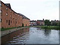
Former Wharf, Chesterfield Canal, Retford
Image: © Geoff Pick
Taken: 30 May 2007
0.10 miles
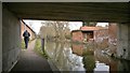
2
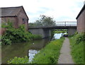
Leverton Road Bridge No 58
Crossing the Chesterfield Canal in the Balk Field area of Retford.
Image: © Mat Fascione
Taken: 28 May 2016
0.10 miles
4
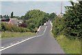
Slow 30 mph
The way into Retford from Leverton , here the road crosses the Chesterfield canal.
Image: © roger geach
Taken: 16 Jun 2008
0.11 miles
5
East of Retford
This houses looks as though it is new, on the site of a smaller building marked on the map. I am trying to identify the source of the cloud of steam on the horizon, probably West Burton power station in SK7985.
Image: © Graham Horn
Taken: 22 Sep 2012
0.12 miles
6
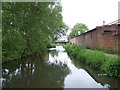
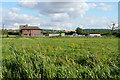
Canal at Balk Field
The Chesterfield Canal runs east of Retford into open fields. The estate of Balk Field is to the left, with individual houses to the right.
Image: © Graham Horn
Taken: 22 Sep 2012
0.12 miles
8
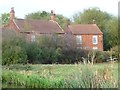
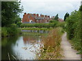
Laurel Cottage and The Laurels
Seen from the Chesterfield Canal, near Clayter's Bridge [no 58].
Image: © Christine Johnstone
Taken: 13 Oct 2011
0.14 miles
9

Chesterfield Canal
View SW near Balk Field
Image: © Richard Croft
Taken: 12 Aug 2010
0.15 miles
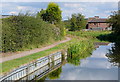
10
By the canal into Retford from the northeast
The canal enters the town via a series of turns as it maintains its level. The houses are by Balk Field.
Image: © Andrew Hill
Taken: 14 Jul 2010
0.15 miles