IMAGES TAKEN NEAR TO
Dentons Way, BRIGG, DN20 9QG
Introduction
This page details the photographs taken nearby to Dentons Way, DN20 9QG by members of the Geograph project.
The Geograph project started in 2005 with the aim of publishing, organising and preserving representative images for every square kilometre of Great Britain, Ireland and the Isle of Man.

There are currently over 7.5m images from over14,400 individuals and you can help contribute to the project by visiting https://www.geograph.org.uk
Image Map (Loading...)


Getting Data...Please wait
Leaflet Map data © OpenStreetMap
Images are licensed for reuse under creativecommons.org/licenses/by-sa/2.0
Notes
- Clicking on the map will re-center to the selected point.
- The higher the marker number, the further away the image location is from the centre of the postcode.
Image Listing (23 Images Found)
Images are licensed for reuse under creativecommons.org/licenses/by-sa/2.0
Image
Details
Distance
1
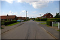
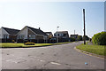
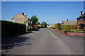
Hibaldstow
Houses at Hibaldstow and Reeson's Mill Image seen from South Carr Road
Image: © Richard Croft
Taken: 26 Nov 2009
0.05 miles
2
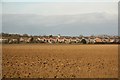
Ings Lane, Hibaldstow
Development since the 1940's has changed this part of Ings Lane into a typical suburban housing area. Picture taken from near the end of Nookings Drive looking West.
Image: © David Wright
Taken: 7 Jun 2006
0.18 miles
4
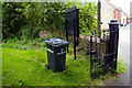
St. Hibald's Wheelie Bin
The church wheelie bin, prominently marked to prevent theft by the unrighteous.
Image: © David Wright
Taken: 7 Jun 2006
0.20 miles
5
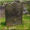
Tombstone of Robert Snowden, died 6th May 1777, aged 11
This tombstone, with a finely cut inscription, is well preserved after 229 years. The local stone does not last well but I prefer its appearance as opposed to Granite or the currently popular Black Marble.
Image: © David Wright
Taken: 7 Jun 2006
0.20 miles
6
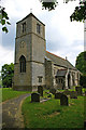
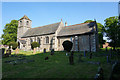
Church of St. Hibald, Hibaldstow
Church of St. Hibald. The church tower fell down during rebuilding in 1875 and was not replaced until 1958 (hence marked as church without spire or tower on 1940's OS map). The new tower is of concrete blocks to look like ashlar and the effect is, to my eye, rather industrial.
Image: © David Wright
Taken: 7 Jun 2006
0.21 miles
8
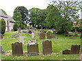
Hibaldstow Churchyard
Churchyard of St. Hibald's. Photo taken looking East.
Image: © David Wright
Taken: 7 Jun 2006
0.22 miles
9
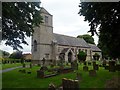
Church of St Hybald
Hybald was a 7th century Saxon saint who was buried in the village. This is one of four churches in Lincolnshire dedicated to him. The church has a grade II listing.
Image: © Graham Hogg
Taken: 28 Jun 2016
0.22 miles