IMAGES TAKEN NEAR TO
Redbourne Road, BRIGG, DN20 9NW
Introduction
This page details the photographs taken nearby to Redbourne Road, DN20 9NW by members of the Geograph project.
The Geograph project started in 2005 with the aim of publishing, organising and preserving representative images for every square kilometre of Great Britain, Ireland and the Isle of Man.

There are currently over 7.5m images from over14,400 individuals and you can help contribute to the project by visiting https://www.geograph.org.uk
Image Map (Loading...)


Getting Data...Please wait
Leaflet Map data © OpenStreetMap
Images are licensed for reuse under creativecommons.org/licenses/by-sa/2.0
Notes
- Clicking on the map will re-center to the selected point.
- The higher the marker number, the further away the image location is from the centre of the postcode.
Image Listing (7 Images Found)
Images are licensed for reuse under creativecommons.org/licenses/by-sa/2.0
Image
Details
Distance
1
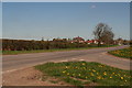
From South Carr Lane, past the dandelions, into Hibaldstow
Image: © Chris
Taken: 26 Apr 2015
0.04 miles
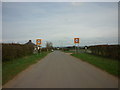
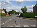
3
Mill Road Hibaldstow
Houses at the eastern end of Mill Road where it forms a junction with the road from Hibaldstow to Redbourne.
Image: © David Squire
Taken: 20 Jan 2006
0.08 miles
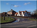
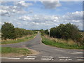
4
South Carr Road at its junction with Redbourne Road (B1206)
Looking westward.
Image: © Peter Wood
Taken: 23 Mar 2024
0.09 miles
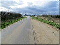
7
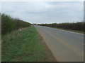
Redbourne Road (B1206)
Heading north towards Hibaldstow.
Image: © JThomas
Taken: 5 Apr 2014
0.24 miles