IMAGES TAKEN NEAR TO
High Street, BARTON-UPON-HUMBER, DN18 6HY
Introduction
This page details the photographs taken nearby to High Street, DN18 6HY by members of the Geograph project.
The Geograph project started in 2005 with the aim of publishing, organising and preserving representative images for every square kilometre of Great Britain, Ireland and the Isle of Man.

There are currently over 7.5m images from over14,400 individuals and you can help contribute to the project by visiting https://www.geograph.org.uk
Image Map (Loading...)


Getting Data...Please wait
Leaflet Map data © OpenStreetMap
Images are licensed for reuse under creativecommons.org/licenses/by-sa/2.0
Notes
- Clicking on the map will re-center to the selected point.
- The higher the marker number, the further away the image location is from the centre of the postcode.
Image Listing (153 Images Found)
Images are licensed for reuse under creativecommons.org/licenses/by-sa/2.0
Image
Details
Distance
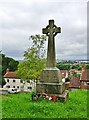
2
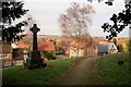
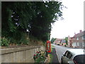
South Ferriby War Memorial
War Memorial in St.Nicholas' churchyard with South Ferriby and the River Humber beyond
Image: © Richard Croft
Taken: 15 Dec 2008
0.02 miles
3
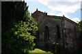
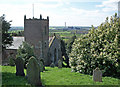
St.Nicholas' church
Kelly's 19th century directory refers to St.Nicholas' as "a mutilated remnant of a much larger church" .... bits of Norman masonry, 13th, 14th and 18th century work, a chancel by Hodgson Fowler in 1889, all jumbled up and turned 90 degrees so the chancel is actually to the south and the tower to the east.
Image: © Richard Croft
Taken: 15 Dec 2008
0.02 miles
4
St.Nicholas' church
Kelly's 19th century directory refers to St.Nicholas' as "a mutilated remnant of a much larger church" .... bits of Norman masonry, 13th, 14th and 18th century work, a chancel by Hodgson Fowler in 1889, all jumbled up and turned 90 degrees so the chancel is actually to the south and the tower to the east.
Image: © Richard Croft
Taken: 15 Dec 2008
0.02 miles
5
Telephone Box defibrillator, South Ferriby
Image: © David Brown
Taken: 11 Jun 2018
0.02 miles
6
South Ferriby Church
Church of St. Nicholas, South Ferriby.
Image: © David Wright
Taken: 18 Apr 2007
0.03 miles
7
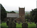
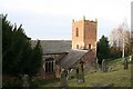
Church of St Nicholas, South Ferriby, from the Viking Way
Of Norman origins, and sited on the west-facing slope of the Lincolnshire Wolds where they meet the Humber. Because of its position on this slope, the church is aligned north-south rather than the usual east-west. The Cemex (formerly Rugby) cement works are to the left of the tower in the distance.
Image: © Tim Heaton
Taken: 2 Jun 2008
0.03 miles
8
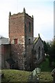
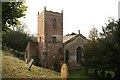
St.Nicholas' church tower
17th and 18th century NE tower of St.Nicholas' church at South Ferriby
Image: © Richard Croft
Taken: 15 Dec 2008
0.03 miles
9
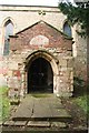
St.Nicholas' church porch
A re-set 14th century doorway with the famous Norman Tympanum http://www.geograph.org.uk/photo/68303 above, reputedly depicting St.Nicholas.
Image: © Richard Croft
Taken: 15 Dec 2008
0.03 miles
10
High Street, South Ferriby, Lincolnshire
War Memorial, erected in memory of those who fell in the Wars of 1914-19 and 1939-45.
A detailed roll of honour may be found here: http://www.roll-of-honour.com/Lincolnshire/SouthFerriby.html
Image: © Bernard Sharp
Taken: 30 Jun 2017
0.03 miles