IMAGES TAKEN NEAR TO
Mill View, BARTON-UPON-HUMBER, DN18 5FN
Introduction
This page details the photographs taken nearby to Mill View, DN18 5FN by members of the Geograph project.
The Geograph project started in 2005 with the aim of publishing, organising and preserving representative images for every square kilometre of Great Britain, Ireland and the Isle of Man.

There are currently over 7.5m images from over14,400 individuals and you can help contribute to the project by visiting https://www.geograph.org.uk
Image Map
Images are licensed for reuse under creativecommons.org/licenses/by-sa/2.0
Notes
- Clicking on the map will re-center to the selected point.
- The higher the marker number, the further away the image location is from the centre of the postcode.
Image Listing (297 Images Found)
Images are licensed for reuse under creativecommons.org/licenses/by-sa/2.0
Image
Details
Distance
1
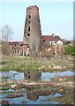
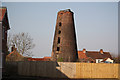
Hewson's Lane Mill, Barton-upon-Humber
Disused windmill off the western end of Hewson's Lane, looking north across a patch of waste ground from Dam Lane.
Image: © Paul Glazzard
Taken: 16 Feb 2008
0.00 miles
2
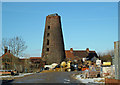
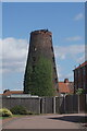
Hewson's Tower Mill, Barton Upon Humber
The redevelopment of this site has proceeded slowly since I visited a year ago Image - presumably due to the current unfavourable economic climate. For more information on this mill see http://microsites.lincolnshire.gov.uk/Windmills/section.asp?catId=3390
Image: © David Wright
Taken: 13 Feb 2009
0.01 miles
3
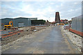
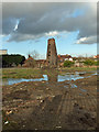
Building Work off Dam Road
Despite the current recession work is continuing on this development near Hewson's Mill.
Image: © David Wright
Taken: 2 Jan 2009
0.01 miles
4
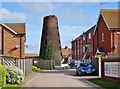
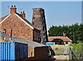
Hewson's Lane, Barton-upon-Humber, Lincolnshire
Eight-storey windmill built in 1813 for Cook & Sutton. The company went bankrupt in 1816 and, after a succession of owners, the mill remained in the Hewson family for over a century from the 1840s. Now derelict and for sale. Viewed from Mill View, Dam Road. Grade II Listed Building https://www.historicengland.org.uk/listing/the-list/list-entry/1039878
Image: © Bernard Sharp
Taken: 13 Apr 2017
0.01 miles
5
Hewson's Mill
Some of the land off Hewson's Lane has been developed http://www.geograph.org.uk/photo/1161104 and named Mill View, though the actual mill view is partially obscured by a high fence.
The derelict seven storey, former 4-sailed tower mill was built in 1813 and worked by wind until some time after WW1, assisted when required by an engine installed in the 1840s. Curiously, it isn't shown on 1:50,000 or 1:25,000 OS maps
Image: © Richard Croft
Taken: 8 Mar 2011
0.01 miles
6
Former Mill off Hewson's Lane
Taken from Mill View, Barton upon Humber.
Image: © Ian S
Taken: 3 Aug 2022
0.01 miles
7
Old Mill, Barton Upon Humber
Photo taken from Dam Road. The land in the foreground appears to be scheduled for development as indicated by the surveyors stakes.
Image: © David Wright
Taken: 5 Feb 2008
0.02 miles
8
Hewson's Lane, Barton-upon-Humber, Lincolnshire
Eight-storey windmill built in 1813 for Cook & Sutton. The company went bankrupt in 1816 and, after a succession of owners, the mill remained in the Hewson family for over a century from the 1840s. The mill is linked to the two-storey house, right. Now derelict and for sale. Viewed from Waterside Road.
Grade II Listed Building https://www.historicengland.org.uk/listing/the-list/list-entry/1039878
Image: © Bernard Sharp
Taken: 10 May 2017
0.02 miles
9
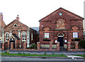
Old Chapel, Waterside Road
This old chapel on Waterside Road now houses a cycle shop.
Image: © David Wright
Taken: 27 Apr 2006
0.02 miles
10
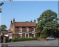
House on Waterside Road
Georgian house on Waterside Road near Maltkiln Road.
Image: © David Wright
Taken: 21 Sep 2006
0.02 miles