IMAGES TAKEN NEAR TO
Burringham Road, SCUNTHORPE, DN17 3LT
Introduction
This page details the photographs taken nearby to Burringham Road, DN17 3LT by members of the Geograph project.
The Geograph project started in 2005 with the aim of publishing, organising and preserving representative images for every square kilometre of Great Britain, Ireland and the Isle of Man.

There are currently over 7.5m images from over14,400 individuals and you can help contribute to the project by visiting https://www.geograph.org.uk
Image Map
Images are licensed for reuse under creativecommons.org/licenses/by-sa/2.0
Notes
- Clicking on the map will re-center to the selected point.
- The higher the marker number, the further away the image location is from the centre of the postcode.
Image Listing (51 Images Found)
Images are licensed for reuse under creativecommons.org/licenses/by-sa/2.0
Image
Details
Distance
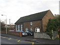
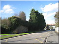
3
Flood debris, Gunness and Burringham School
On the night of 5th December 2013 the River Trent overflowed its banks between Gunness and Burringham. The school was extensively flooded and though superficially there does not appear to be much damage the school will remain closed until February 2014 with the total cost of repairs running to about £200,000.
Image: © Jonathan Thacker
Taken: 6 Dec 2013
0.14 miles
4
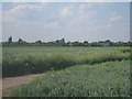
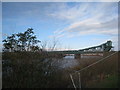
Althorpe - River Trent to south of Keadby Bridge
Image: © Dave Bevis
Taken: 26 Nov 2009
0.15 miles
5
Abandoned railway bridge abutment
The South Yorkshire Railway first crossed the Trent at Keadby on a rail-only bridge in 1866. This was replaced by the present Keadby Bridge in 1916 on an alignment a little to the north. In this picture can be seen an abutment of the original bridge and part of its successor where it crosses Burringham Road.
Image: © Jonathan Thacker
Taken: 17 Oct 2012
0.16 miles
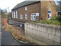
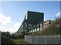
6
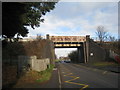
Railway bridge over Burringham Road
Image: © Jonathan Thacker
Taken: 23 Nov 2010
0.17 miles
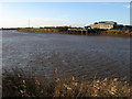
7
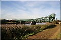
Keadby Bridge
The King George V swing bridge was opened by the King in 1916
The Scherzer rolling lift bridge carrying both road and rail traffic across the River Trent was built by the Great Central Railway 1912-16, replacing the rail only swing bridge of 1866 built by the South Yorkshire Railway Company.
Its 163ft electricity powered bascule (lifting span) was one of the first of its type in Britain and when built, was the largest in Europe. Designed by James Ball and built by contractors Sir.William Arrol & Co. it has three main spans and two approach spans, the total distance between abutments is 548ft. The bascule was fixed in position in 1960, when the bridge was widened and the headroom increased and hasn’t been lifted since.
Each span is composed of three lattice steel girders, the middle one of which runs between the road and the railway. The main spans are 134ft, 140ft and the bascule one, which provides a clear waterway of 150ft. The approach span to the east is 70ft wide and the western one, onto which the bascule span rolls, is 40ft wide.
Image: © Richard Croft
Taken: 3 Nov 2006
0.18 miles
8
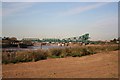
Keadby Bridge
Keadby Bridge http://www.geograph.org.uk/photo/272609 from the east bank
Image: © Richard Croft
Taken: 3 Nov 2006
0.18 miles
10
King George V Bridge
Generally known simply as Keadby Bridge. Opened in 1916 as a combined road and rail bridge and replacing a rail-only bridge of 1866 situated slightly to the south. The eastern section originally lifted but this has been fixed since 1960.
Image: © Jonathan Thacker
Taken: 17 Oct 2012
0.19 miles