IMAGES TAKEN NEAR TO
Wisteria Way, SCUNTHORPE, DN16 3AQ
Introduction
This page details the photographs taken nearby to Wisteria Way, DN16 3AQ by members of the Geograph project.
The Geograph project started in 2005 with the aim of publishing, organising and preserving representative images for every square kilometre of Great Britain, Ireland and the Isle of Man.

There are currently over 7.5m images from over14,400 individuals and you can help contribute to the project by visiting https://www.geograph.org.uk
Image Map (Loading...)


Getting Data...Please wait
Leaflet Map data © OpenStreetMap
Images are licensed for reuse under creativecommons.org/licenses/by-sa/2.0
Notes
- Clicking on the map will re-center to the selected point.
- The higher the marker number, the further away the image location is from the centre of the postcode.
Image Listing (31 Images Found)
Images are licensed for reuse under creativecommons.org/licenses/by-sa/2.0
Image
Details
Distance
1
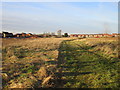
Brat Hill housing
Much of the land in the foreground will eventually be developed for housing.
Image: © Jonathan Thacker
Taken: 7 Feb 2018
0.04 miles
3
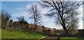
End of Crowberry Drive
With Brat Hill beyond the fence. Potential housing site?
Image: © Chris Morgan
Taken: 5 Feb 2020
0.10 miles
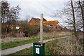
4
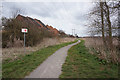
Path leading to Wisteria Way
Taken from the Opencast Way.
Image: © Ian S
Taken: 21 Mar 2016
0.11 miles
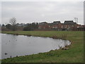
5
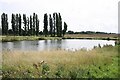
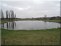
Brat Hill pond
Pond near Bottesford with Holme Hall Golf Club beyond the Poplar trees
Image: © Richard Croft
Taken: 2 Sep 2008
0.11 miles
6
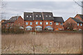
Houses on Mulberry Gardens
Taken from the Opencast Way.
Image: © Ian S
Taken: 21 Mar 2016
0.12 miles
7
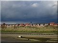
Lakeside Parkway and new housing, Brat Hill
At present the largest expansion of housing in Scunthorpe is in the extreme south-east. Soon there will be a switch to areas to the west of the town as part of the "Lincolnshire Lakes" project.
Image: © Jonathan Thacker
Taken: 1 Mar 2017
0.12 miles
9
Bottesford Beck Linear Park
Taken while walking the Opencast Way.
Image: © Ian S
Taken: 21 Mar 2016
0.14 miles