IMAGES TAKEN NEAR TO
Coverdale Road, SCUNTHORPE, DN16 2RP
Introduction
This page details the photographs taken nearby to Coverdale Road, DN16 2RP by members of the Geograph project.
The Geograph project started in 2005 with the aim of publishing, organising and preserving representative images for every square kilometre of Great Britain, Ireland and the Isle of Man.

There are currently over 7.5m images from over14,400 individuals and you can help contribute to the project by visiting https://www.geograph.org.uk
Image Map (Loading...)


Getting Data...Please wait
Leaflet Map data © OpenStreetMap
Images are licensed for reuse under creativecommons.org/licenses/by-sa/2.0
Notes
- Clicking on the map will re-center to the selected point.
- The higher the marker number, the further away the image location is from the centre of the postcode.
Image Listing (12 Images Found)
Images are licensed for reuse under creativecommons.org/licenses/by-sa/2.0
Image
Details
Distance
1
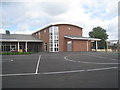
St. Peter and St. Paul Church of England Primary School
A new school due to open in September 2012.
Image: © Jonathan Thacker
Taken: 22 Aug 2012
0.09 miles
2
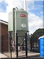
Pellet hopper
At St. Peter and St. Paul Church of England Primary School.
Image: © Jonathan Thacker
Taken: 22 Aug 2012
0.09 miles
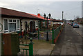
3
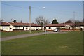
Uredale Place
1950s prefabs in Uredale Place
Image: © Richard Croft
Taken: 6 Mar 2009
0.14 miles
4
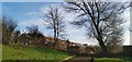
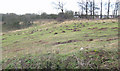
End of Crowberry Drive
With Brat Hill beyond the fence. Potential housing site?
Image: © Chris Morgan
Taken: 5 Feb 2020
0.15 miles
5
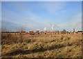
Brat Hill housing
Scunthorpe steelworks in the background showing above the rooftops.
Image: © Jonathan Thacker
Taken: 7 Feb 2018
0.16 miles
6
Molehills at Brat Hill, Scunthorpe
For unknown reasons there is at present a marked proliferation of Moles in North Lincolnshire http://www.thisisscunthorpe.co.uk/news/Moles-invade-North-Lincs/article-611504-detail/article.html
Image: © David Wright
Taken: 17 Jan 2009
0.18 miles
7
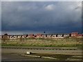
Lakeside Parkway and new housing, Brat Hill
At present the largest expansion of housing in Scunthorpe is in the extreme south-east. Soon there will be a switch to areas to the west of the town as part of the "Lincolnshire Lakes" project.
Image: © Jonathan Thacker
Taken: 1 Mar 2017
0.19 miles
8
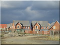
New housing, Brat Hill
At present the largest expansion of housing in Scunthorpe is in the extreme south-east. Soon there will be a switch to areas to the west of the town as part of the "Lincolnshire Lakes" project.
Image: © Jonathan Thacker
Taken: 1 Mar 2017
0.19 miles
9
Derwent Road, Scunthorpe
A road with a large number of what appear to be prefab dwellings, all in a good state of repair.
Image: © Paul Harrop
Taken: 30 Jan 2009
0.20 miles
10
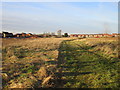
Brat Hill housing
Much of the land in the foreground will eventually be developed for housing.
Image: © Jonathan Thacker
Taken: 7 Feb 2018
0.21 miles