IMAGES TAKEN NEAR TO
Willow Close, GOOLE, DN14 9RH
Introduction
This page details the photographs taken nearby to Willow Close, DN14 9RH by members of the Geograph project.
The Geograph project started in 2005 with the aim of publishing, organising and preserving representative images for every square kilometre of Great Britain, Ireland and the Isle of Man.

There are currently over 7.5m images from over14,400 individuals and you can help contribute to the project by visiting https://www.geograph.org.uk
Image Map (Loading...)


Getting Data...Please wait
Leaflet Map data © OpenStreetMap
Images are licensed for reuse under creativecommons.org/licenses/by-sa/2.0
Notes
- Clicking on the map will re-center to the selected point.
- The higher the marker number, the further away the image location is from the centre of the postcode.
Image Listing (13 Images Found)
Images are licensed for reuse under creativecommons.org/licenses/by-sa/2.0
Image
Details
Distance
1
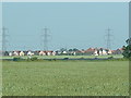
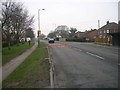
Snaith, South Parkway
The photograph was taken from Park Lane West Cowick
Image: © Gordon Kneale Brooke
Taken: 21 Jun 2006
0.10 miles
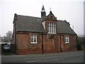
4
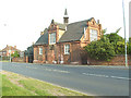
Snaith Grammar School
Dating from 1878 but no longer a school building
Image: © Graham Hogg
Taken: 30 Jun 2015
0.17 miles
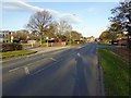
6
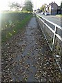
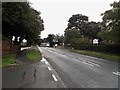
Pedestrian barrier alongside the A645 Snaith
Image: © Steve Fareham
Taken: 1 Nov 2014
0.18 miles
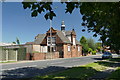
7
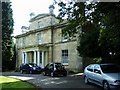
Snaith Hall, Pontefract Road
Built in 1829 for William Shearburn a local solicitor and landowner, used now as a care home.
Image: © Stanley Walker
Taken: 31 Aug 2010
0.20 miles