IMAGES TAKEN NEAR TO
Thorne Road, GOOLE, DN14 8SY
Introduction
This page details the photographs taken nearby to Thorne Road, DN14 8SY by members of the Geograph project.
The Geograph project started in 2005 with the aim of publishing, organising and preserving representative images for every square kilometre of Great Britain, Ireland and the Isle of Man.

There are currently over 7.5m images from over14,400 individuals and you can help contribute to the project by visiting https://www.geograph.org.uk
Image Map
Images are licensed for reuse under creativecommons.org/licenses/by-sa/2.0
Notes
- Clicking on the map will re-center to the selected point.
- The higher the marker number, the further away the image location is from the centre of the postcode.
Image Listing (6 Images Found)
Images are licensed for reuse under creativecommons.org/licenses/by-sa/2.0
Image
Details
Distance
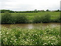
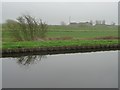
1
River Don
The lower levels of the River Don give little to indicate that this river once flowed through some of the most polluted industrial areas in the country.
Image: © Michael Patterson
Taken: 26 Jun 2006
0.14 miles
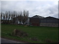
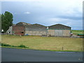
4
Poplars Farm
Seen from the barge Sobriety, heading from Goole to Sprotbrough.
Image: © Christine Johnstone
Taken: 4 Apr 2014
0.23 miles