IMAGES TAKEN NEAR TO
Mond Avenue, GOOLE, DN14 6LQ
Introduction
This page details the photographs taken nearby to Mond Avenue, DN14 6LQ by members of the Geograph project.
The Geograph project started in 2005 with the aim of publishing, organising and preserving representative images for every square kilometre of Great Britain, Ireland and the Isle of Man.

There are currently over 7.5m images from over14,400 individuals and you can help contribute to the project by visiting https://www.geograph.org.uk
Image Map (Loading...)


Getting Data...Please wait
Leaflet Map data © OpenStreetMap
Images are licensed for reuse under creativecommons.org/licenses/by-sa/2.0
Notes
- Clicking on the map will re-center to the selected point.
- The higher the marker number, the further away the image location is from the centre of the postcode.
Image Listing (10 Images Found)
Images are licensed for reuse under creativecommons.org/licenses/by-sa/2.0
Image
Details
Distance
1
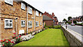
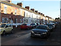
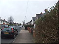
Westfield Avenue, Goole
Pasture Road, one of the main shopping streets of Goole, becomes Westfield Avenue as the shops end and residential properties begin; the modern row of houses separated from the road by garden is Kirkby Close.
Image: © Trevor Littlewood
Taken: 4 Jul 2012
0.18 miles
3
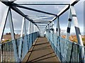
Railway footbridge
The bridge crosses the Doncaster-Hull railway line.
Image: © Graham Hogg
Taken: 8 Dec 2014
0.22 miles
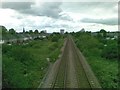
8
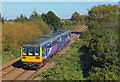
Train near Goole
Passenger train approaching Goole.
Image: © Wayland Smith
Taken: 21 Sep 2019
0.25 miles