IMAGES TAKEN NEAR TO
Balk Lane, GOOLE, DN14 5NQ
Introduction
This page details the photographs taken nearby to Balk Lane, DN14 5NQ by members of the Geograph project.
The Geograph project started in 2005 with the aim of publishing, organising and preserving representative images for every square kilometre of Great Britain, Ireland and the Isle of Man.

There are currently over 7.5m images from over14,400 individuals and you can help contribute to the project by visiting https://www.geograph.org.uk
Image Map (Loading...)


Getting Data...Please wait
Leaflet Map data © OpenStreetMap
Images are licensed for reuse under creativecommons.org/licenses/by-sa/2.0
Notes
- Clicking on the map will re-center to the selected point.
- The higher the marker number, the further away the image location is from the centre of the postcode.
Image Listing (13 Images Found)
Images are licensed for reuse under creativecommons.org/licenses/by-sa/2.0
Image
Details
Distance
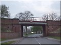
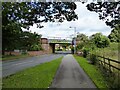
2
Railway Bridge over Hook Road, Goole
Image: © Bill Henderson
Taken: 27 Mar 2008
0.11 miles
3
Hook Road Railway Bridge
At trackside level on the left-hand wall and facing away from the camera is possibly an Ordnance Survey flush bracket benchmark 2208. See https://www.bench-marks.org.uk/bm9892 for info on the mark.
Image: © Brian Westlake
Taken: 16 Sep 2022
0.12 miles
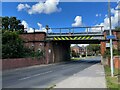
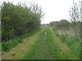
4
Railway Bridge
Across Hook Road and appearing to serve as the boundary between Hook and Goole
Image: © Kevin Waterhouse
Taken: 18 Sep 2023
0.12 miles
8
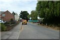
Road works on Hook High Street
The road ahead was closed to motor vehicles.
Image: © DS Pugh
Taken: 17 Jun 2023
0.21 miles
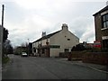
9
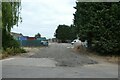
Construction site in Hook
Construction beside Hook High Street.
Image: © DS Pugh
Taken: 17 Jun 2023
0.21 miles