IMAGES TAKEN NEAR TO
Heck & Pollington Lane, GOOLE, DN14 0DA
Introduction
This page details the photographs taken nearby to Heck & Pollington Lane, DN14 0DA by members of the Geograph project.
The Geograph project started in 2005 with the aim of publishing, organising and preserving representative images for every square kilometre of Great Britain, Ireland and the Isle of Man.

There are currently over 7.5m images from over14,400 individuals and you can help contribute to the project by visiting https://www.geograph.org.uk
Image Map
Images are licensed for reuse under creativecommons.org/licenses/by-sa/2.0
Notes
- Clicking on the map will re-center to the selected point.
- The higher the marker number, the further away the image location is from the centre of the postcode.
Image Listing (10 Images Found)
Images are licensed for reuse under creativecommons.org/licenses/by-sa/2.0
Image
Details
Distance
1
Pollington Airfield, WWII Hangar
Image: © Gordon Kneale Brooke
Taken: 21 Jan 2006
0.04 miles
2
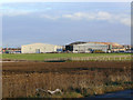
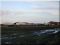
Hangars at Pollington
This was the Snaith (Pollington) airfield, originally part of No.1 Group, Bomber Command. The hangars have been converted to industrial use.
The rounded roof hangar is a J-type, the other two are T-type.
Image: © Alan Murray-Rust
Taken: 27 Dec 2011
0.05 miles
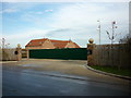
4
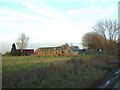
Industrial buildings near Pollington
On the site of the former RAF Snaith.
Image: © Jonathan Thacker
Taken: 17 Jan 2018
0.07 miles
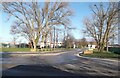
5
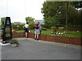
Memorial and Memorial Garden at Pollington airfield
The airfield was opened in 1941 and served as RAF Snaith until 1946 it is also known as Pollington airfield after the local village and is now a large industrial estate with this memorial and garden in its midst, it commemorates the 892 aircrew who lost their lives in bombing raids
Image: © Martin Dawes
Taken: 27 Sep 2006
0.08 miles
6
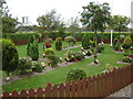
Pollington Airfield Memorial Garden
Pollington/ RAF Snaith was a bomber airfield from 1941-46
Image: © Martin Dawes
Taken: 27 Sep 2006
0.09 miles
7
World War 2 Building on Pollington Airfield (disused)
Image: © Bill Henderson
Taken: 2 Mar 2007
0.18 miles
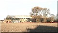
8
The Old Officers Mess
This house is built on the Pollington Airfield.
Image: © Ian S
Taken: 3 Nov 2010
0.19 miles
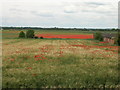
9
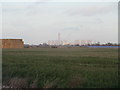
View towards Drax power station
Looking across what was once the airfield of RAF Snaith.
Image: © Jonathan Thacker
Taken: 17 Jan 2018
0.25 miles