IMAGES TAKEN NEAR TO
Christ Church Road, DONCASTER, DN1 2QS
Introduction
This page details the photographs taken nearby to Christ Church Road, DN1 2QS by members of the Geograph project.
The Geograph project started in 2005 with the aim of publishing, organising and preserving representative images for every square kilometre of Great Britain, Ireland and the Isle of Man.

There are currently over 7.5m images from over14,400 individuals and you can help contribute to the project by visiting https://www.geograph.org.uk
Image Map
Images are licensed for reuse under creativecommons.org/licenses/by-sa/2.0
Notes
- Clicking on the map will re-center to the selected point.
- The higher the marker number, the further away the image location is from the centre of the postcode.
Image Listing (127 Images Found)
Images are licensed for reuse under creativecommons.org/licenses/by-sa/2.0
Image
Details
Distance
1
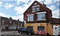
The Ewa Mini Market on Copley Road, Doncaster
Specialising in East European foods. The building has a 1890 datestone above the top windows.
Image: © Christine Johnstone
Taken: 1 Sep 2014
0.03 miles
2
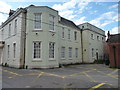
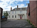
East side, Nether Hall
Grade 2 listed building. Built in the early or mid 1700s and later altered. A First World War Drill Hall. Now used by Doncaster Council as offices.
Image: © Christine Johnstone
Taken: 1 Sep 2014
0.06 miles
3
Nether Hall - viewed from Christ Church Road
Image: © Betty Longbottom
Taken: 16 May 2015
0.06 miles
4
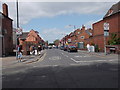
Christ Church Road - Nether Hall Road
Image: © Betty Longbottom
Taken: 16 May 2015
0.07 miles
5
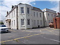
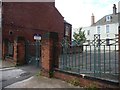
Entrance on south side, Nether Hall
Grade 2 listed building. Built in the early or mid 1700s and later altered. A First World War Drill Hall. Now used by Doncaster Council as offices.
Image: © Christine Johnstone
Taken: 1 Sep 2014
0.07 miles
6
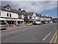
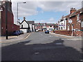
Parade of Shops - Nether Hall Road
Image: © Betty Longbottom
Taken: 16 May 2015
0.08 miles
7
Grab yourself a bargain on Broxholme Lane
The shop, at the corner of Copley Road, was built by the Doncaster Mutual Cooperative Industrial Society in 1884.
Image: © Christine Johnstone
Taken: 1 Sep 2014
0.08 miles
8
Entrance to Nether Hall, Nether Hall Road
Grade 2 listed building. Built in the early or mid 1700s and later altered. A First World War Drill Hall. Now used by Doncaster Council as offices.
Image: © Christine Johnstone
Taken: 1 Sep 2014
0.09 miles
9
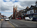
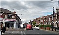
Nether Hall Road, Doncaster
Looking north-east, out of town. The imposing church has been converted to flats
Image: © Christine Johnstone
Taken: 1 Sep 2014
0.09 miles
10
Broxholme Lane - Nether Hall Road
Image: © Betty Longbottom
Taken: 16 May 2015
0.09 miles