IMAGES TAKEN NEAR TO
Harrogate Drive, DONCASTER, DN12 4ND
Introduction
This page details the photographs taken nearby to Harrogate Drive, DN12 4ND by members of the Geograph project.
The Geograph project started in 2005 with the aim of publishing, organising and preserving representative images for every square kilometre of Great Britain, Ireland and the Isle of Man.

There are currently over 7.5m images from over14,400 individuals and you can help contribute to the project by visiting https://www.geograph.org.uk
Image Map
Images are licensed for reuse under creativecommons.org/licenses/by-sa/2.0
Notes
- Clicking on the map will re-center to the selected point.
- The higher the marker number, the further away the image location is from the centre of the postcode.
Image Listing (6 Images Found)
Images are licensed for reuse under creativecommons.org/licenses/by-sa/2.0
Image
Details
Distance
1
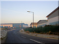
Eland Road Industrial Estate Denaby
-2 degrees centigrade this morning.
Image: © Steve Fareham
Taken: 12 Feb 2008
0.15 miles
2
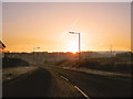
A frosty morning with the sun rising over Conisbrough
Image: © Steve Fareham
Taken: 12 Feb 2008
0.16 miles
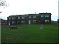
5
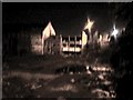
Construction house Mexborough at 4.00am
This is the derelict building near the train station in Mexborough which used to be construction house. I took this on my phone at 4.00am and it's got a real spooky aura to it.
Image: © steve peet
Taken: 3 May 2011
0.24 miles
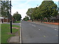
6
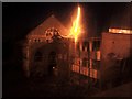
Construction house Mexborough
This is my 2nd submission of photos taken at 4.00am of the construction house building in Mexborough but taken in a different light. Even though the building is in a dangerous state of dereliction, this one doesn't seem to show it?
Image: © steve peet
Taken: 3 May 2011
0.24 miles