IMAGES TAKEN NEAR TO
Water Fir Drive, DONCASTER, DN11 8ND
Introduction
This page details the photographs taken nearby to Water Fir Drive, DN11 8ND by members of the Geograph project.
The Geograph project started in 2005 with the aim of publishing, organising and preserving representative images for every square kilometre of Great Britain, Ireland and the Isle of Man.

There are currently over 7.5m images from over14,400 individuals and you can help contribute to the project by visiting https://www.geograph.org.uk
Image Map
Images are licensed for reuse under creativecommons.org/licenses/by-sa/2.0
Notes
- Clicking on the map will re-center to the selected point.
- The higher the marker number, the further away the image location is from the centre of the postcode.
Image Listing (22 Images Found)
Images are licensed for reuse under creativecommons.org/licenses/by-sa/2.0
Image
Details
Distance
1

Development in Harworth
Significant new house building is underway in Harworth as the old pithead tower looms over the former pit village.
Image: © Neil Theasby
Taken: 12 Jan 2016
0.10 miles
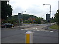
2

Outside Harworth All Saints Primary School
Looking to Harworth Colliery's pithead tower. There are three figures of children by Scrooby Road - no doubt intended to urge passing drivers to quell their speed. On the opposite side of the road brand new housing development is in progress.
Image: © Neil Theasby
Taken: 12 Jan 2016
0.12 miles

6
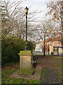
Drinking fountain on Harworth Green
Of inderterminate age, and without any inscription, but it could be a Millennium project.
Image: © Alan Murray-Rust
Taken: 24 Nov 2014
0.14 miles
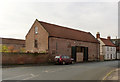
7
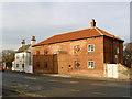
Dovecote Barn, Main Street
Early 19th century (dated 181?) barn, converted to residential use. Listed Grade II.
Image: © Alan Murray-Rust
Taken: 24 Nov 2014
0.15 miles
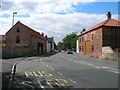
8
Willow Tree Barn, Main Street
Formerly attached to Grange Farm, now converted as a separate dwelling. Late 18th century, Listed Grade II.
Image: © Alan Murray-Rust
Taken: 24 Nov 2014
0.17 miles
9
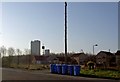
Blue bins
On Scrooby Road with the head gear of Harworth Colliery in the background.
Image: © Steve Fareham
Taken: 15 Apr 2008
0.17 miles
10
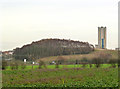
View from Styrrup Road
The plantation is modern, designed to screen the colliery. The winding tower to No.1 shaft of Harworth Colliery, designed by Sir Basil Spence, is a distinctive local landmark.
Image: © Alan Murray-Rust
Taken: 24 Nov 2014
0.17 miles