IMAGES TAKEN NEAR TO
Everton, DONCASTER, DN10 5BZ
Introduction
This page details the photographs taken nearby to DN10 5BZ by members of the Geograph project.
The Geograph project started in 2005 with the aim of publishing, organising and preserving representative images for every square kilometre of Great Britain, Ireland and the Isle of Man.

There are currently over 7.5m images from over14,400 individuals and you can help contribute to the project by visiting https://www.geograph.org.uk
Image Map
Images are licensed for reuse under creativecommons.org/licenses/by-sa/2.0
Notes
- Clicking on the map will re-center to the selected point.
- The higher the marker number, the further away the image location is from the centre of the postcode.
Image Listing (5 Images Found)
Images are licensed for reuse under creativecommons.org/licenses/by-sa/2.0
Image
Details
Distance
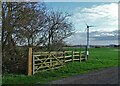
2
Bridleway junctions at Everton Carr farm
Rich fertile sandy farmland.
Image: © Steve Fareham
Taken: 21 Mar 2009
0.05 miles
3
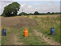
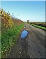
Gas Bottle Barrier
These gas bottles appear to be acting as some sort of barrier to this field. A footpath runs by the side of the blue bottle to the right and across the edge of the field to the River Idle barrier bank.
Image: © Michael Patterson
Taken: 16 Aug 2006
0.09 miles
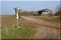
4
Footpath to Barrier Bank
By Everton Carr Farm.
Image: © Jonathan Thacker
Taken: 31 Jul 2012
0.10 miles
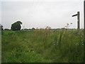
5
Black Bank near Everton Carr Farm
Black Bank heads in a north easterly direction before turning sharply south west and following a straight line to Roe Lane in this pancake flat landscape.
Image: © Neil Theasby
Taken: 19 Nov 2020
0.14 miles