IMAGES TAKEN NEAR TO
Gringley Road, DONCASTER, DN10 4PG
Introduction
This page details the photographs taken nearby to Gringley Road, DN10 4PG by members of the Geograph project.
The Geograph project started in 2005 with the aim of publishing, organising and preserving representative images for every square kilometre of Great Britain, Ireland and the Isle of Man.

There are currently over 7.5m images from over14,400 individuals and you can help contribute to the project by visiting https://www.geograph.org.uk
Image Map (Loading...)


Getting Data...Please wait
Leaflet Map data © OpenStreetMap
Images are licensed for reuse under creativecommons.org/licenses/by-sa/2.0
Notes
- Clicking on the map will re-center to the selected point.
- The higher the marker number, the further away the image location is from the centre of the postcode.
Image Listing (60 Images Found)
Images are licensed for reuse under creativecommons.org/licenses/by-sa/2.0
Image
Details
Distance
1
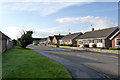
The Paddocks, Beckingham
1960s/70s bungalow development on the north west side of the village.
Image: © Alan Murray-Rust
Taken: 4 Nov 2014
0.11 miles
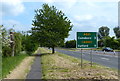
3
Bus stop, postbox and kissing gate
The postbox (ref no DN10 228) is a standard early EVIIR wall box with widened letter slot.
The kissing gate is an unusually tall example, the reason for this being obscure. The horizontal rails of the swinging gate have spikes, presumably to stop joyriders.
Image: © Alan Murray-Rust
Taken: 4 Nov 2014
0.13 miles
4
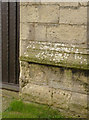
Bench mark and bolt, All Saints Church, Beckingham
A wider view than http://www.geograph.org.uk/photo/4191283 to show the relation to the west door and the ground.
Image: © Alan Murray-Rust
Taken: 28 Sep 2014
0.13 miles
5
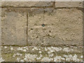
Bench mark and bolt, All Saints Church, Beckingham
Without the presence of the bolt, this bench mark would be almost invisible, and is clearer in the photograph than to the naked eye.
It was a branch level of the London to Doncaster line used during the first primary levelling of England and Wales between 1840 and 1860. http://www.bench-marks.org.uk/bm28125 See also http://www.geograph.org.uk/photo/4191284 and http://www.geograph.org.uk/photo/4191282 for location.
Image: © Alan Murray-Rust
Taken: 28 Sep 2014
0.13 miles
6
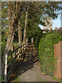
Path near the church
Old maps show this as crossing an open paddock; now there are houses to the right and on the left an extension of the church graveyard.
Image: © Alan Murray-Rust
Taken: 4 Nov 2014
0.13 miles
8
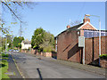
High Street, Beckingham
There is a bench mark http://www.geograph.org.uk/photo/4241718 on the high wall at the right hand side.
Image: © Alan Murray-Rust
Taken: 9 Nov 2014
0.14 miles
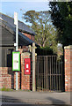
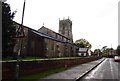
9
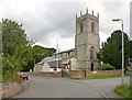
Church of All Saints, Beckingham
View from the north-west. The new toilet and kitchen block has not yet had time to mellow. There is a bench mark http://www.geograph.org.uk/photo/4191283 just to the right of the west door.
The churchyard wall dates back to the late 18th century, restored 1900 http://www.geograph.org.uk/photo/4191288 . Listed Grade II for group value.
Image: © Alan Murray-Rust
Taken: 28 Sep 2014
0.14 miles
10
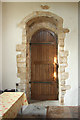
North doorway
Late 11th or early 12th century north doorway in All Saints' church http://www.geograph.org.uk/photo/2913806
Image: © Richard Croft
Taken: 28 Mar 2012
0.14 miles