IMAGES TAKEN NEAR TO
Constable Burton, LEYBURN, DL8 5RP
Introduction
This page details the photographs taken nearby to DL8 5RP by members of the Geograph project.
The Geograph project started in 2005 with the aim of publishing, organising and preserving representative images for every square kilometre of Great Britain, Ireland and the Isle of Man.

There are currently over 7.5m images from over14,400 individuals and you can help contribute to the project by visiting https://www.geograph.org.uk
Image Map
Images are licensed for reuse under creativecommons.org/licenses/by-sa/2.0
Notes
- Clicking on the map will re-center to the selected point.
- The higher the marker number, the further away the image location is from the centre of the postcode.
Image Listing (13 Images Found)
Images are licensed for reuse under creativecommons.org/licenses/by-sa/2.0
Image
Details
Distance
1
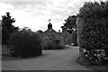
Low Hutton
Attractive property in secluded spot.
Image: © Tony Simms
Taken: 30 Jun 2015
0.01 miles
2
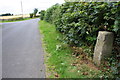
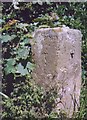
No Man's Moor Lane approaching junction of road to Hutton Hang
There are two OS benchmarks Image on the base of the stone guide post in the right foreground
Image: © Roger Templeman
Taken: 14 Aug 2016
0.02 miles
3
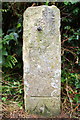
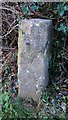
Guide post/gatepost with double benchmarks
Ordnance Survey cut mark benchmarks described on the Bench Mark Database at http://www.bench-marks.org.uk/bm72015
Image: © Roger Templeman
Taken: 14 Aug 2016
0.02 miles
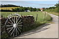
4
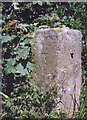
Milestone / Guidepost, No Man's Moor Lane
At Low Hutton, east of the junction with the road to Hutton Hang. Benchmarks (2) both representing 487.4 ft ASL.
More views https://www.geograph.org.uk/photo/4767315 - https://www.geograph.org.uk/photo/5311283 - https://www.geograph.org.uk/photo/5311264
Leyburn : (Hutt)on : Burton (Constable Burton)
Milestone Society National ID: YN_XLEYc
Image: © Milestone Society
Taken: 18 Nov 2020
0.02 miles
5
Old Guide Stone by Low Hutton, Leyburn parish
Guide Stone by the UC road, in parish of Leyburn (Richmondshire District), Low Hutton, East of junction with Hutton Hang and Hutton Hill in No Man's Moor Lane. Original location was directly opposite junction.
Inscription reads:-
: Leyburn : : Middleh / am :
North Yorkshire HER.
NY SMR Number: MNY36625 https://www.heritagegateway.org.uk/Gateway/Results_Single.aspx?uid=MNY36625&resourceID=1009
Surveyed
Milestone Society National ID: YN_XLEYc
Image: © Milestone Society
Taken: Unknown
0.03 miles
6
Guidepost with Cut Bench Marks
This old stone has a large cut bench mark on its south face. On the east face it has Bedale written at the top, and the west face it may have said Leyburn but it is hard to read due to weathering. Due to the damage on the top left corner the writing on this face has been lost.
Image: © Matthew Hatton
Taken: 6 Dec 2015
0.03 miles
8
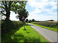
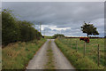
National Cycle Route 71, Low Hutton
Towards Hutton Hang.
Image: © JThomas
Taken: 24 Jul 2020
0.07 miles
9
Access Lane leading onto No Man's Moor Lane
Image: © Chris Heaton
Taken: 7 Oct 2017
0.18 miles
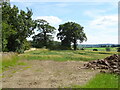
10
Footpath via Fox Covert
The public footpath follows the track and then runs alongside the right hand side of the house in the distance.
Image: © Andrew Whale
Taken: 9 Jul 2010
0.20 miles