IMAGES TAKEN NEAR TO
Shawl Quarry Lane, LEYBURN, DL8 5BU
Introduction
This page details the photographs taken nearby to Shawl Quarry Lane, DL8 5BU by members of the Geograph project.
The Geograph project started in 2005 with the aim of publishing, organising and preserving representative images for every square kilometre of Great Britain, Ireland and the Isle of Man.

There are currently over 7.5m images from over14,400 individuals and you can help contribute to the project by visiting https://www.geograph.org.uk
Image Map
Images are licensed for reuse under creativecommons.org/licenses/by-sa/2.0
Notes
- Clicking on the map will re-center to the selected point.
- The higher the marker number, the further away the image location is from the centre of the postcode.
Image Listing (20 Images Found)
Images are licensed for reuse under creativecommons.org/licenses/by-sa/2.0
Image
Details
Distance
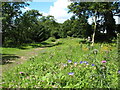
1
![A circular walk from Leyburn via Wensley village [10]](https://s3.geograph.org.uk/geophotos/07/32/67/7326791_6cb77884_120x120.jpg)
A circular walk from Leyburn via Wensley village [10]
After running alongside the woodland for some distance, the path now enters Leyburn Shawl Plantation.
From Leyburn the route runs west along the ridge of Leyburn Shawl before descending to Tullis Cote and, after crossing the railway, heading southeast toward the village of Wensley. After passing through Wensley the route is northeast across fields and, after recrossing the railway, returning to the starting point. About 5½ miles.
Image: © Michael Dibb
Taken: 24 Jun 2022
0.03 miles
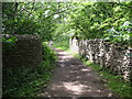
2
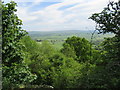
Leyburn Shawl footpath
The path along the Shawl passes through woodland for much of its length, offering occasional views over Wensleydale.
Image: © Gordon Hatton
Taken: 20 Jul 2008
0.04 miles
3
![A circular walk from Leyburn via Wensley village [11]](https://s0.geograph.org.uk/geophotos/07/32/67/7326792_c0af659a_120x120.jpg)
A circular walk from Leyburn via Wensley village [11]
The path continues to run along the ridge of Leyburn Shawl in Leyburn Shawl Plantation.
From Leyburn the route runs west along the ridge of Leyburn Shawl before descending to Tullis Cote and, after crossing the railway, heading southeast toward the village of Wensley. After passing through Wensley the route is northeast across fields and, after recrossing the railway, returning to the starting point. About 5½ miles.
Image: © Michael Dibb
Taken: 24 Jun 2022
0.06 miles
4
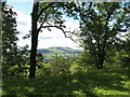
Leyburn Shawl
Much of the Shawl is well wooded, but gaps in the trees afford splendid views over Wensleydale, like this one towards Penhill.
Image: © Gordon Hatton
Taken: 20 Jul 2008
0.06 miles
5
![A circular walk from Leyburn via Wensley village [9]](https://s3.geograph.org.uk/geophotos/07/32/57/7325755_2c14aa24_120x120.jpg)
A circular walk from Leyburn via Wensley village [9]
The path heads across the field with Dale View in the distance.
From Leyburn the route runs west along the ridge of Leyburn Shawl before descending to Tullis Cote and, after crossing the railway, heading southeast toward the village of Wensley. After passing through Wensley the route is northeast across fields and, after recrossing the railway, returning to the starting point. About 5½ miles.
Image: © Michael Dibb
Taken: 24 Jun 2022
0.06 miles
6
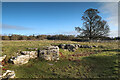
Limestone outcrop on Leyburn Shawl
Leyburn Shawl and its continuation Redmire Scar, are formed as an escarpment on the Main Limestone, and the public footpath follows the top of the outcrop to the west from Leyburn. This makes for a pretty much level walk, with splendid vistas over Wensleydale where the view is not obscured by trees, but the limestone, being underfoot and below a layer of soil, is mostly not visible. Here just the top of the bed pokes out of the field, just off the footpath. Behind the Shawl (ie. to the north), the limestone is being extracted by a large and noisy quarry, which, along with constant machine gun fire from Bellerby ranges further north again, rather spoils the tranquility of the walk. Probably Sundays are a better choice than midweek !
Image: © Andy Waddington
Taken: 20 Jan 2022
0.09 miles
7
![A circular walk from Leyburn via Wensley village [12]](https://s1.geograph.org.uk/geophotos/07/32/67/7326793_7cd27f87_120x120.jpg)
A circular walk from Leyburn via Wensley village [12]
The path passes through a clearing in Leyburn Shawl Plantation.
From Leyburn the route runs west along the ridge of Leyburn Shawl before descending to Tullis Cote and, after crossing the railway, heading southeast toward the village of Wensley. After passing through Wensley the route is northeast across fields and, after recrossing the railway, returning to the starting point. About 5½ miles.
Image: © Michael Dibb
Taken: 24 Jun 2022
0.15 miles
9
Bridge on the Shawl footpath
The photographer would be the first to admit that this isn't the best ever photo of a bridge, but to capture an image of the stone arch would involve either a 10m abseil down a rockface, or a longer route through head high nettles. [neither appealed] The bridge spans a narrow and deep cut through the limestone where once ran a railway line connecting Moor Quarry with the Wensleydale line below.
Image: © Gordon Hatton
Taken: 20 Jul 2008
0.18 miles
10
![A circular walk from Leyburn via Wensley village [8]](https://s1.geograph.org.uk/geophotos/07/32/57/7325753_fb34f6c1_120x120.jpg)
A circular walk from Leyburn via Wensley village [8]
The path continues to run on the field edge alongside the woodland of Leyburn Shawl Plantation.
From Leyburn the route runs west along the ridge of Leyburn Shawl before descending to Tullis Cote and, after crossing the railway, heading southeast toward the village of Wensley. After passing through Wensley the route is northeast across fields and, after recrossing the railway, returning to the starting point. About 5½ miles.
Image: © Michael Dibb
Taken: 24 Jun 2022
0.19 miles