IMAGES TAKEN NEAR TO
Burrill, BEDALE, DL8 1RU
Introduction
This page details the photographs taken nearby to DL8 1RU by members of the Geograph project.
The Geograph project started in 2005 with the aim of publishing, organising and preserving representative images for every square kilometre of Great Britain, Ireland and the Isle of Man.

There are currently over 7.5m images from over14,400 individuals and you can help contribute to the project by visiting https://www.geograph.org.uk
Image Map
Images are licensed for reuse under creativecommons.org/licenses/by-sa/2.0
Notes
- Clicking on the map will re-center to the selected point.
- The higher the marker number, the further away the image location is from the centre of the postcode.
Image Listing (10 Images Found)
Images are licensed for reuse under creativecommons.org/licenses/by-sa/2.0
Image
Details
Distance
1
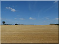
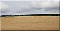
Wheat field at Mudfields Farm
The name of the farm seemed particularly inappropriate in the middle of the summer 2018 heatwave.
Image: © Stephen Craven
Taken: 14 Jul 2018
0.01 miles
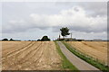
4
Mudfields Farm Crossing
Rural farm accommodation crossing the private railway line in open country.
Image: © roger geach
Taken: 1 May 2011
0.16 miles
6
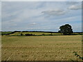
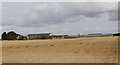
Cereal crop north of National Cycle Route 71
Image: © JThomas
Taken: 24 Jul 2020
0.22 miles
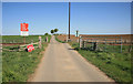
8
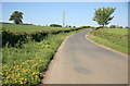
Junction of Sinks Lane and Moor End Lane
There is a culverted drain Image under the road joining the ditch along the right hand side of Sinks Lane
Image: © Roger Templeman
Taken: 5 Jul 2015
0.24 miles
9
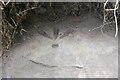
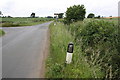
Benchmark on culvert near Cote House Farm
Ordnance Survey pivot benchmark described on the Bench Mark Database at http://www.bench-marks.org.uk/bm68681
Image: © Roger Templeman
Taken: 5 Jul 2015
0.25 miles
10
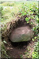
Culvert on north side of Sinks Lane east of Cote House Farm
There is an OS benchmark Image on the upper surface of the stone forming the culvert top
Image: © Roger Templeman
Taken: 5 Jul 2015
0.25 miles