IMAGES TAKEN NEAR TO
Leeming, NORTHALLERTON, DL7 9SZ
Introduction
This page details the photographs taken nearby to DL7 9SZ by members of the Geograph project.
The Geograph project started in 2005 with the aim of publishing, organising and preserving representative images for every square kilometre of Great Britain, Ireland and the Isle of Man.

There are currently over 7.5m images from over14,400 individuals and you can help contribute to the project by visiting https://www.geograph.org.uk
Image Map
Images are licensed for reuse under creativecommons.org/licenses/by-sa/2.0
Notes
- Clicking on the map will re-center to the selected point.
- The higher the marker number, the further away the image location is from the centre of the postcode.
Image Listing (23 Images Found)
Images are licensed for reuse under creativecommons.org/licenses/by-sa/2.0
Image
Details
Distance
1
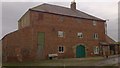
Mill Farm, Leeming
18thC Corn Mill with attached dwelling. This property was sold by auction in May 2013, the previous incumbent had lived here for 65 years, and in all that time the mill had flooded just once in Sept 2012.
The new owner told me that sadly the milling machinery had been removed in the late 1940's, but the building still has many interesting features.
Image: © Matthew Hatton
Taken: 10 Jan 2014
0.08 miles
2
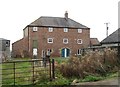
Mill Farm Leeming
Although surrounded by barns and sheds, this doesn't look much like a typical Yorkshire farm house, which isn't surprising as it was once the village corn mill, the mill race once running along a channel immediately to the right of the gate. Another surprising thing is that the mill doesn't appear as a listed building.
Image: © Gordon Hatton
Taken: 6 Nov 2018
0.08 miles
3
Sluice Gate, Mill Farm
Rustic charm in this oak-planked sluice.
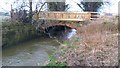
The A1(M) atops the embankment in the background.
Image: © Matthew Hatton
Taken: 10 Jan 2014
0.09 miles
4
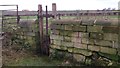
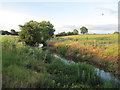
The lock that never was
Plans to canalise the River Swale and Bedale Beck in the 1760's never came to fruition and the scheme collapsed. There is some debate as to whether this lock at Leeming was ever completed, but all that remains now are the well constructed side walls. Another lock that was finished is at Topcliffe in SE3976. In nearby Bedale one can walk or drive down 'Harbour View' a road that leads to the site of the harbour where there is an information board and metal mooring rings.
Image: © Gordon Hatton
Taken: 6 Nov 2018
0.15 miles
5
Brick bridge over Bedale Beck
This part of Bedale Beck is known as Main Cut, this was down to it being part of the proposed Bedale Navigation. A grand scheme to link Bedale with the Swale, Ure & Ouse in the late 18thC, the work began at Bedale building a stone lined dock and the beck was straighten, here there was a lock built, the large stone wall is part of it, there are slots for the lock gates hidden under the ivy. However the scheme went bust, the gates were never built and the local mill owner built this brick bridge over the beck to link to Bedale market.
The timber pailling is part of the Sustrans improvements to the bridleway.
Image: © Matthew Hatton
Taken: 10 Jan 2014
0.16 miles
6
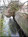
Bedale Beck at Leeming Lock
In the late 18th century it was planned to make the Bedale Beck navigable from the River Swale to the town of Bedale. A harbour was constructed in Bedale and a lock at Leeming, the remains of which lie between the trees in the foreground of this picture. Unfortunately the plans to make the Swale and Bedale Beck navigable were never completed.
Image: © David Tyers
Taken: 15 Jun 2018
0.16 miles
7
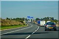
Exelby, Leeming and Londonderry : A1(M)
Looking north on the A1(M).
Image: © Lewis Clarke
Taken: 21 Sep 2020
0.17 miles
8
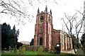
Leeming, Church of St John The Baptist
This Church is just to the south west of centre of the O/S grid it occupies
Image: © Bill Henderson
Taken: Unknown
0.18 miles
9
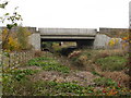
Two bridges over Bedale Beck
The relatively recent concrete structure nearer the camera carries the A1(M) over Bedale Beck, whilst beyond, the bridge carrying the A6055 can just be seen.
Image: © Gordon Hatton
Taken: 6 Nov 2018
0.19 miles
10
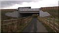
Sustrans Bridleway under new A1(M)
Eddie Stobbart Articulated Lorry crosses Bedale Beck under which the rerouted bridleway passes.
Image: © Matthew Hatton
Taken: 10 Jan 2014
0.20 miles