IMAGES TAKEN NEAR TO
Hilton Garth, NORTHALLERTON, DL7 9PJ
Introduction
This page details the photographs taken nearby to Hilton Garth, DL7 9PJ by members of the Geograph project.
The Geograph project started in 2005 with the aim of publishing, organising and preserving representative images for every square kilometre of Great Britain, Ireland and the Isle of Man.

There are currently over 7.5m images from over14,400 individuals and you can help contribute to the project by visiting https://www.geograph.org.uk
Image Map
Images are licensed for reuse under creativecommons.org/licenses/by-sa/2.0
Notes
- Clicking on the map will re-center to the selected point.
- The higher the marker number, the further away the image location is from the centre of the postcode.
Image Listing (22 Images Found)
Images are licensed for reuse under creativecommons.org/licenses/by-sa/2.0
Image
Details
Distance
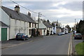
1
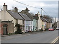
Village street, Londonderry.
Strange how these rendered and painted cottages in Londonderry North Yorkshire look as though they might belong in Londonderry NI. Brick or stone would be more usual here. Londonderry has been bypassed by the A1 and is now a 'dead end' village.
Image: © Gordon Hatton
Taken: 5 Mar 2007
0.03 miles
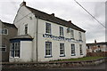
2
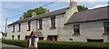
Crosby House
Originally built as The Cleaveland Arms Coaching Inn, for weary travellers heading up & down the Great North Road. It ceased to be a public house in the early 20thC but it is still a fine building.
The A1 bypassed Londonderry in the 1960s when it was turned into a dual carriageway.
Image: © Matthew Hatton
Taken: 16 May 2020
0.03 miles
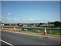
3
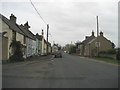
Londonderry
Londonderry used to straddle the Great North Road until the Leeming by-pass was opened in the early 1960s. Traffic is now much lighter !
Image: © TIM CHAPMAN
Taken: 5 Mar 2007
0.04 miles
4
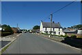
Road near Crosby Farm
Looking through the village of Londonderry beside the A1.
Image: © DS Pugh
Taken: 10 Jul 2022
0.06 miles
5
Londonderry - The Yorkshire Version
It does actually take its name from the city in Northern Ireland.
This used to be on the Great North Road, but has been reduced to a dead end that serves the village only - since the upgrading of the A1 to motorway status.
This has strangled the life and business from the community, which has now the rather run down look of yesteryear.
Image: © Chris Heaton
Taken: 21 Mar 2016
0.07 miles
7
Milepost on old A1 at Londonderry
One of the earliest mileposts made by Mattisons of Bedale when roads were cared for by Highways Districts. Conventionally when travelling towards a milepost the name of the next town is indicated on that face. On a few of these posts the hands were cast pointing the wrong way and a new correct hand was fixed over the wrong one.
Now on a dead end section of road.
Image: © Hilary Jones
Taken: 1 Sep 2020
0.09 miles
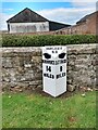
8

Old Milepost by Crosby Farm, Londonderry, Bedale parish
Cast iron post by the UC road (was A1), in parish of BEDALE (HAMBLETON District), Londonderry, South end of cut off road, in front of low wall by Crosby Farm, on East side of road. Bedale casting, erected by an unknown authority in the 19th century.
Inscription reads:-
: {<-hand} / BOROBRIDGE / 14 / MILES : : HANG.EAST / H.D : : {hand->} / CATTERICK / 8 / MILES :
Milestone Society National ID: YN_BBCT14.
Image: © C Minto
Taken: 22 Feb 2013
0.09 miles
9
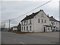
Londonderry Lodge
Trucker's heaven with mountainous meals, giant mugs of tea and a bed for the night. Londonderry Lodge is a 'pit stop' for trucks on the A1.
Image: © Gordon Hatton
Taken: 5 Mar 2007
0.12 miles
10
Londonderry Lodge
There is an OS benchmark Image on the near corner left of the grey downpipe
Image: © Roger Templeman
Taken: 16 Jun 2013
0.15 miles