IMAGES TAKEN NEAR TO
Little Holtby, NORTHALLERTON, DL7 9LW
Introduction
This page details the photographs taken nearby to DL7 9LW by members of the Geograph project.
The Geograph project started in 2005 with the aim of publishing, organising and preserving representative images for every square kilometre of Great Britain, Ireland and the Isle of Man.

There are currently over 7.5m images from over14,400 individuals and you can help contribute to the project by visiting https://www.geograph.org.uk
Image Map
Images are licensed for reuse under creativecommons.org/licenses/by-sa/2.0
Notes
- Clicking on the map will re-center to the selected point.
- The higher the marker number, the further away the image location is from the centre of the postcode.
Image Listing (21 Images Found)
Images are licensed for reuse under creativecommons.org/licenses/by-sa/2.0
Image
Details
Distance
1
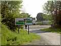
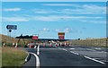
North or South?
Junction of Bowbridge Lane and the A1.
Image: © Steve Fareham
Taken: 5 Jun 2008
0.05 miles
2
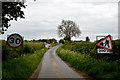
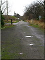
Bowbridge Lane approaching A1
A site of large scale construction of the A1 motorway. This small lane will ultimately join the relief road (A6055 or A6136 depending on whether the Ripon relief comes north or the Catterick road goes south!).
Image: © Tony Simms
Taken: 27 May 2015
0.07 miles
3
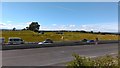
A1(M) at St. Ann's Cross
The traffic is now even further away than it was when Oliver Dixon geographed this area in 2005. The new A1(M) carriageway improvements are still on going, but there is now no access to it from Holtby Grange.
Image: © Matthew Hatton
Taken: 16 Jul 2016
0.07 miles
4
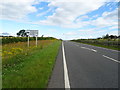
A6055 towards Catterick
Road running parallel to the upgraded A1(M) at this point.
Image: © JThomas
Taken: 1 Aug 2020
0.07 miles
5
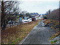
The end of the road - for now
The newly opened section of A6055 to the north of Leeming Bar currently [August 2016] goes this far and no further, unless you wish to visit Goskins Farm. So here one must turn left into the narrow Bowbridge Lane which heads towards Hackforth. In the distance can be seen a new bridge over the upgraded A1[M], which I suspect carries this new road over the motorway and onwards towards Catterick. Only a matter of time before we can find out.
Image: © Gordon Hatton
Taken: 22 Aug 2016
0.08 miles
6

Ainderby Miers with Holtby : A1(M)
Looking north on the A1(M).
Image: © Lewis Clarke
Taken: 21 Sep 2020
0.09 miles
7
Dere Street
Looking roughly southeast along a now bypassed part of the A1 near Holtby Grange. The catseyes are still visible.
Image: © David Rogers
Taken: 24 Nov 2009
0.09 miles
8
A1 at Holtby Grange
Looking north. Showing section of old cut-off road
Image: © Oliver Dixon
Taken: 18 Mar 2006
0.09 miles
9
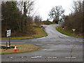
Bowbridge Lane
Junction on the A1 near St Ann's Cross leading to Hackforth and Hornby.
Image: © David Rogers
Taken: 24 Nov 2009
0.10 miles
10
Dere Street from St. Ann's Cross
This quiet back water is the true line of Dere Street, the Roman Road that ran from Eboracum (York) to Veluniate (Bo'ness) on the Antonine Wall. It has now been bypassed twice by successive widenings of the A1 to the west.
Image: © Matthew Hatton
Taken: 16 Jul 2016
0.11 miles