IMAGES TAKEN NEAR TO
Ainderby Road, NORTHALLERTON, DL7 9JR
Introduction
This page details the photographs taken nearby to Ainderby Road, DL7 9JR by members of the Geograph project.
The Geograph project started in 2005 with the aim of publishing, organising and preserving representative images for every square kilometre of Great Britain, Ireland and the Isle of Man.

There are currently over 7.5m images from over14,400 individuals and you can help contribute to the project by visiting https://www.geograph.org.uk
Image Map
Images are licensed for reuse under creativecommons.org/licenses/by-sa/2.0
Notes
- Clicking on the map will re-center to the selected point.
- The higher the marker number, the further away the image location is from the centre of the postcode.
Image Listing (10 Images Found)
Images are licensed for reuse under creativecommons.org/licenses/by-sa/2.0
Image
Details
Distance
1
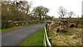
Howden Bridge
Howden Bridge is a Scheduled Monument number 193, as listed by Hambleton District Council. It used to carry the A684 Ainderby Road over the River Wiske until the nearby Viewly Bridge was built in 1956.
Image: © David Rogers
Taken: 23 Feb 2009
0.09 miles
2
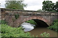
Howden Bridge over River Wiske
An Ordnance Survey 1GL bolt benchmark was cut on this bridge during the First primary levelling, England & Wales, and was levelled with a height of 93.9210 feet [28.6271 metres] above mean sea level (Liverpool datum). It was included as a side level on the Selby to Newcastle-upon-Tyne levelling line which was surveyed during August 1842 to February 1845. The surveyor's description was 'No. 102(e). Howden Bridge over River Wisk. Bolt in North face and E. pier ; 8.20 ft. below coping'. The OS Abstract describing this and neighbouring marks along line may be found at http://www.deformedweb.co.uk/trigs/data/1GL/1GLA_378.png. See also entry in the Bench Mark Database at http://www.bench-marks.org.uk/bm43706
Image: © Roger Templeman
Taken: 17 Jun 2012
0.09 miles
3
Viewly Bridge
View from Howden Bridge of Viewly Bridge which was built in 1956.
Image: © David Rogers
Taken: 23 Feb 2009
0.09 miles
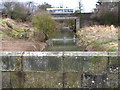
5
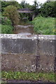
Benchmark on parapet of Howden Bridge
Looking towards the newer Viewly Bridge which carries the A684 over the river. The Ordnance Survey cut mark benchmark is described on the Bench Mark Database at http://www.bench-marks.org.uk/bm32995
Image: © Roger Templeman
Taken: 17 Jun 2012
0.09 miles
6
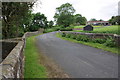
Howden Bridge
This bridge is Grade II listed:
Bridge. C15 and late C19. Ashlar and coursed squared stone. 2 western
pointed chamfered arches are medieval with ribbed archivolts and, between
them, a triangular-section cutwater rising into pedestrian retreat. Eastern
C19 segmental arch has voussoirs and pilasters breaking forward to either
side. Band corbelled across pilasters. Parapet. Half the bridge is in the
parish of Romanby.
There is an OS benchmark Image on the right hand parapet.
Image: © Roger Templeman
Taken: 17 Jun 2012
0.09 miles
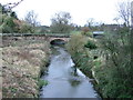
7
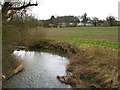
River Wiske
View from Howden Bridge looking towards Hall Farm at Warlaby. The river moves in to gridsquare SE3591 as it bends left in this shot.
Image: © David Rogers
Taken: 23 Feb 2009
0.10 miles
8
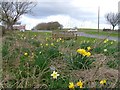
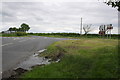
Memorial Seat, Ainderby Road
With the Yafforth/Warlaby crossroads behind.
Image: © Mick Garratt
Taken: 14 Apr 2006
0.22 miles
9
Cross roads of minor roads with A684
Ahead to Yafforth, behind from Warlaby
Image: © Roger Templeman
Taken: 17 Jun 2012
0.24 miles
10
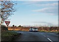
Approaching the A684
Seen from the minor road heading north from Newby Wiske, where it reaches a cross roads junction with A684. The road ahead continues towards Yafforth and is much used by traffic heading towards the northern end of Northallerton, thus avoiding the busy town centre and two level crossings.
Image: © Gordon Hatton
Taken: 7 Jan 2022
0.24 miles