IMAGES TAKEN NEAR TO
South Otterington, NORTHALLERTON, DL7 9HG
Introduction
This page details the photographs taken nearby to DL7 9HG by members of the Geograph project.
The Geograph project started in 2005 with the aim of publishing, organising and preserving representative images for every square kilometre of Great Britain, Ireland and the Isle of Man.

There are currently over 7.5m images from over14,400 individuals and you can help contribute to the project by visiting https://www.geograph.org.uk
Image Map
Images are licensed for reuse under creativecommons.org/licenses/by-sa/2.0
Notes
- Clicking on the map will re-center to the selected point.
- The higher the marker number, the further away the image location is from the centre of the postcode.
Image Listing (35 Images Found)
Images are licensed for reuse under creativecommons.org/licenses/by-sa/2.0
Image
Details
Distance
1
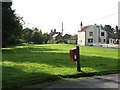
The Green, Little Otterington
South Otterington is a village with an odd layout. The main development is along the A167, but parallel to that is another 'main street' which is also a cul de sac. This area is known locally as 'Little Otterington'.
Image: © Gordon Hatton
Taken: 25 Sep 2008
0.01 miles
2
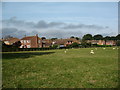
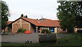
The village hall
South Otterington village hall is near the south end of the 'Little Otterington' area of the village.
Image: © Gordon Hatton
Taken: 25 Sep 2008
0.06 miles
3
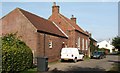
Housing development, South Otterington
Housing dating mostly from the 1980's has partly filled the gap between South and Little Otterington. Any further development across the field would destroy a medieval field system, which would be a shame.
Image: © Gordon Hatton
Taken: 25 Sep 2008
0.06 miles
5
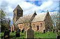
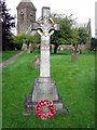
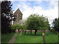
South Otterington, St Andrew's Church
This Church is central in the western quarter of the O/S grid it occupies.
Image: © Bill Henderson
Taken: Unknown
0.09 miles
6
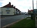
South Otterington
The main street (A167) through the village. On the left is the village pub, The Otterington Shorthorn. The building is early 19c but the name must date to the 18c when advances in breeding techniques produced bigger cattle than the traditional breeds. The biggest bulls became very famous and very valuable.
Image: © Mick Garratt
Taken: 14 Apr 2006
0.09 miles
7
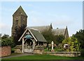
St Andrews Parish Church
Rebuilt in 1846 on the site of a late Norman structure.
Image: © David Rogers
Taken: 11 Jan 2010
0.10 miles
8
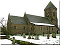
St Andrew's church, South Otterington
Built in the 1840's in a neo Norman style. A rather heavy design in dark sandstone with an odd little pyramid roof on the tower.
Image: © Gordon Hatton
Taken: 25 Sep 2008
0.10 miles
10
South Otterington School
A C of E primary school serving South Otterington, Newby Wiske and surrounding area. The attractive building dates from the early nineties.
Image: © Gordon Hatton
Taken: 25 Sep 2008
0.11 miles