IMAGES TAKEN NEAR TO
Alverton Lane, NORTHALLERTON, DL7 8TP
Introduction
This page details the photographs taken nearby to Alverton Lane, DL7 8TP by members of the Geograph project.
The Geograph project started in 2005 with the aim of publishing, organising and preserving representative images for every square kilometre of Great Britain, Ireland and the Isle of Man.

There are currently over 7.5m images from over14,400 individuals and you can help contribute to the project by visiting https://www.geograph.org.uk
Image Map
Images are licensed for reuse under creativecommons.org/licenses/by-sa/2.0
Notes
- Clicking on the map will re-center to the selected point.
- The higher the marker number, the further away the image location is from the centre of the postcode.
Image Listing (149 Images Found)
Images are licensed for reuse under creativecommons.org/licenses/by-sa/2.0
Image
Details
Distance
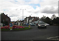
2
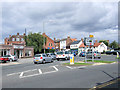
Northallerton - Roundabout at High Street (southern end)
The roundabout at the end of South Parade with High Street to the left, East Road ahead, and Thirsk Road to the right (out of picture).
Image: © David Ward
Taken: 27 Jul 2007
0.07 miles
3
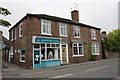
Yorkshire Cancer Research, #32 Romanby Road
Image: © Roger Templeman
Taken: 20 May 2012
0.07 miles
4
Romanby Road
Viewed from where Alverton Lane crosses at one of a plague of mini roundabouts that have hit the town recently. The curved brickwork in the distance is on Church House which used to hold the Church of England Sunday School.
Image: © Bob Embleton
Taken: 18 Jun 2007
0.07 miles
6
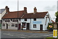
The Nags Head & Alexander Optometrists, Northallerton
A couple of quite ancient buildings, nicely restored and presented, at the south end of Northallerton High Street
Image: © Tony Simms
Taken: 6 May 2015
0.08 miles
7
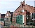
Headquarters, 4th Battalion, Green Howards
The central section of Northallerton's First World War Drill Hall, on the west side of Thirsk Road.
Image: © Christine Johnstone
Taken: 2 Apr 2015
0.08 miles
8
Northallerton's World War One Drill Hall
On the west side of Thirsk Road, near the junction with the A167.
Image: © Christine Johnstone
Taken: 2 Apr 2015
0.08 miles
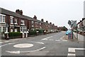
9
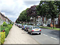
Northallerton - South Parade
A general view along South Parade a little way from the station and heading towards the town centre.
Image: © David Ward
Taken: 27 Jul 2007
0.08 miles
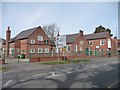
10
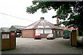
Northallerton Cattle Mart
The octagonal building was used for the auctions of cattle who were paraded around in the centre whilst the farmers and or butchers lined the walls on raised platforms bidding. Sometimes lucky children got to parade the animals around in the early 1960s :-).
Image: © Bob Embleton
Taken: 18 Jun 2007
0.09 miles