IMAGES TAKEN NEAR TO
Cypress Close, DARLINGTON, DL3 8QR
Introduction
This page details the photographs taken nearby to Cypress Close, DL3 8QR by members of the Geograph project.
The Geograph project started in 2005 with the aim of publishing, organising and preserving representative images for every square kilometre of Great Britain, Ireland and the Isle of Man.

There are currently over 7.5m images from over14,400 individuals and you can help contribute to the project by visiting https://www.geograph.org.uk
Image Map
Images are licensed for reuse under creativecommons.org/licenses/by-sa/2.0
Notes
- Clicking on the map will re-center to the selected point.
- The higher the marker number, the further away the image location is from the centre of the postcode.
Image Listing (9 Images Found)
Images are licensed for reuse under creativecommons.org/licenses/by-sa/2.0
Image
Details
Distance
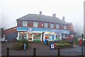
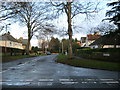
2
Blackwell Scar Darlington
A cul-de-sac in the Blackwell area of the town
Image: © Peter Robinson
Taken: 3 Dec 2009
0.12 miles
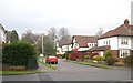
3
A Road called Blackwell
This rather tidy suburban thoroughfare on the outskirts of Darlington has been adopted by the Teesdale Way on its journey towards the North Sea.
Image: © Chris Heaton
Taken: 4 Nov 2009
0.13 miles
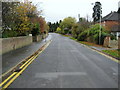
4
Teesdale Way approaching Castle Hill
The trail is following the River Tees to a small section of woodland that conceals Castle Hill, - part of the Darlington suburb of Blackwell.
Image: © Chris Heaton
Taken: 4 Nov 2009
0.14 miles
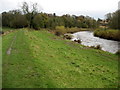
5
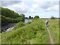
The Teesdale Way near Blackwell
The Teesdale Way is a 148 km long path running from Dufton in Cumbria through to the Tees estuary.
Image: © Oliver Dixon
Taken: 10 Aug 2017
0.20 miles
6
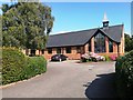
All Saints and Salutation Parish Church and Millennium Centre, Darlington
Image: © Bill Henderson
Taken: 23 Aug 2019
0.20 miles
7
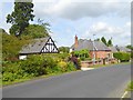
Houses on Blackwell
A suburb of Darlington near the River Tees.
Image: © Oliver Dixon
Taken: 10 Aug 2017
0.22 miles
9
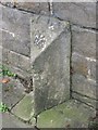
Old Boundary Marker by the A67, Carmel Road South, Darlington
Boundary Marker by the A67, in parish of Darlington (Darlington District), Carmel Road South, near Elm Ridge Methodist Church, against wall outside Greenways Mews.
Surveyed
Milestone Society National ID: DU_DAHLAbm
Image: © Milestone Society
Taken: Unknown
0.24 miles