IMAGES TAKEN NEAR TO
Hylton Road, FERRYHILL, DL17 8QP
Introduction
This page details the photographs taken nearby to Hylton Road, DL17 8QP by members of the Geograph project.
The Geograph project started in 2005 with the aim of publishing, organising and preserving representative images for every square kilometre of Great Britain, Ireland and the Isle of Man.

There are currently over 7.5m images from over14,400 individuals and you can help contribute to the project by visiting https://www.geograph.org.uk
Image Map
Images are licensed for reuse under creativecommons.org/licenses/by-sa/2.0
Notes
- Clicking on the map will re-center to the selected point.
- The higher the marker number, the further away the image location is from the centre of the postcode.
Image Listing (5 Images Found)
Images are licensed for reuse under creativecommons.org/licenses/by-sa/2.0
Image
Details
Distance
2
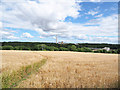
Permissive path through barley field
Permissive paths are not uncommon but this one is unusual as it cuts right through a growing cash crop rather than crossing open country or a grassed field for grazing. It gives an alternative access to Ferryhill Carrs Nature Reserve.
Image: © Trevor Littlewood
Taken: 15 Aug 2017
0.17 miles
3
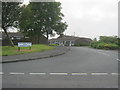
Wood Lane, Ferryhill
An attractive welcome to the town
Image: © Oliver Dixon
Taken: 20 Apr 2006
0.17 miles
4
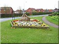
Cleves Cross, Ferryhill
Marking the site near where Sir Roger de Fery slew the 'Brawn of Brancepeth' in 1200AD. For the 'fairy story' about this encounter see mention in http://forteanzoology.blogspot.com/2009_05_14_archive.html
Image: © Courtesy Mr John Dinning of Ferryhill
Taken: 26 Jan 2010
0.22 miles