IMAGES TAKEN NEAR TO
SPENNYMOOR, DL16 7QR
Introduction
This page details the photographs taken nearby to DL16 7QR by members of the Geograph project.
The Geograph project started in 2005 with the aim of publishing, organising and preserving representative images for every square kilometre of Great Britain, Ireland and the Isle of Man.

There are currently over 7.5m images from over14,400 individuals and you can help contribute to the project by visiting https://www.geograph.org.uk
Image Map
Images are licensed for reuse under creativecommons.org/licenses/by-sa/2.0
Notes
- Clicking on the map will re-center to the selected point.
- The higher the marker number, the further away the image location is from the centre of the postcode.
Image Listing (10 Images Found)
Images are licensed for reuse under creativecommons.org/licenses/by-sa/2.0
Image
Details
Distance
1
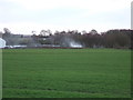
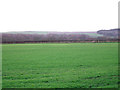
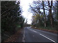
Young crop field, New Town
Looking south towards Bishop's Close Cottages.
Image: © JThomas
Taken: 6 Dec 2015
0.12 miles
2
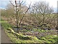
Auckland Way
The Clarence Railway opened 1837, ran between Spennymoor and Bishop Auckland. The trackbed has now been converted into the Auckland Way http://www.cobr.co.uk/e-cobr_information/cycling_initiatives/sections/rail_trails/auckland_way/text.shtml , an attractive path for walkers and cyclists.
Image: © Oliver Dixon
Taken: 18 Feb 2007
0.14 miles
4
Wayside pond on the Auckland Way
The Clarence Railway opened 1837, ran between Spennymoor and Bishop Auckland. The trackbed has now been converted into the Auckland Way http://www.cobr.co.uk/e-cobr_information/cycling_initiatives/sections/rail_trails/auckland_way/text.shtml , an attractive path for walkers and cyclists. To assist drainage, a number of channels and ponds have been excavated alongside the path.
Image: © Oliver Dixon
Taken: 18 Feb 2007
0.17 miles
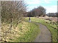
6
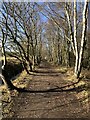
Auckland Way Railway Path
The Auckland Way uses the former railway alignment between Bishop Auckland and Spennymoor. The earliest part of the railway opened in 1841, linking Byers Green to the Clarence Railway's route to Teesside at Ferryhill. The Clarence Railway was en early competitor to the Stockton & Darlington Railway, active in the transportation of coal from Durham collieries to ports on the Tees. The North Eastern Railway extended the line in 1885, infilling the gap between Bishop Auckland and Byers Green. The last part to open was the first to lose its passenger service in 1939, the remaining services to Spennymoor were withdrawn in 1952.
Image: © David Robinson
Taken: 1 Mar 2022
0.22 miles
7
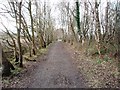
Auckland Walk near Bishop's Close Wood
This photograph shows a section of the Auckland Way. This is a walk-way/cycle-way that runs along the route of the old dis-used railway track that used to link Spennymoor and Bishop Auckland. This picture was taken looking in a west-south-westerly direction towards Old Park Terrace.
Image: © Philip Barker
Taken: 27 Jan 2010
0.23 miles
8
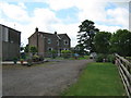
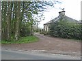
Bishop's Close Farmhouse
Situated just west of Spennymoor County Durham
Image: © Peter Robinson
Taken: 21 Jun 2009
0.23 miles
9
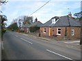
New Town, near Spennymoor
Bungalows on the Whitworth Road.
Image: © Oliver Dixon
Taken: 16 Apr 2007
0.24 miles