IMAGES TAKEN NEAR TO
Lower Bridge Street, BISHOP AUCKLAND, DL14 7QB
Introduction
This page details the photographs taken nearby to Lower Bridge Street, DL14 7QB by members of the Geograph project.
The Geograph project started in 2005 with the aim of publishing, organising and preserving representative images for every square kilometre of Great Britain, Ireland and the Isle of Man.

There are currently over 7.5m images from over14,400 individuals and you can help contribute to the project by visiting https://www.geograph.org.uk
Image Map
Images are licensed for reuse under creativecommons.org/licenses/by-sa/2.0
Notes
- Clicking on the map will re-center to the selected point.
- The higher the marker number, the further away the image location is from the centre of the postcode.
Image Listing (57 Images Found)
Images are licensed for reuse under creativecommons.org/licenses/by-sa/2.0
Image
Details
Distance
1
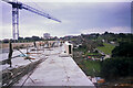
Newton Cap Viaduct, Bishop Auckland
Installation of the pre-cast concrete parapet units to the west side of the viaduct.
Image: © Philip Soakell
Taken: 6 Sep 1994
0.01 miles
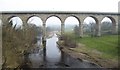
2
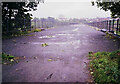
Newton Cap Viaduct, Bishop Auckland
Newton Cap Viaduct was originally built between 1854 and 1857 to carry the Bishop Auckland to Durham railway across the River Wear
Construction works took place between 1993 and 1995 to convert the viaduct to carry road traffic (A689) over the River Wear.
Image]
Image: © Philip Soakell
Taken: 13 Sep 1993
0.02 miles
3
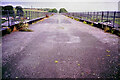
Newton Cap Viaduct, Bishop Auckland
Newton Cap Viaduct was originally built between 1854 and 1857 to carry the Bishop Auckland to Durham railway across the River Wear
Construction works took place between 1993 and 1995 to convert the viaduct to carry road traffic (A689) over the River Wear.
Image]
Image: © Philip Soakell
Taken: 13 Sep 1993
0.02 miles
4
Newton Cap Viaduct
Looking across the viaduct over the River Wear. This viaduct once carried the Durham to Bishop Auckland Railway Line. National Cycle Network route 715 crosses the viaduct.
Image: © DS Pugh
Taken: 9 Sep 2023
0.02 miles
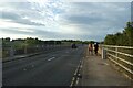
6

Cycle path beside the A689 on the Newton Cap Viaduct
Looking south east.
Originally built as a railway viaduct it closed in 1968 and was re-opened to carry the A689 in 1995.
Image: © JThomas
Taken: 24 Aug 2017
0.04 miles
7
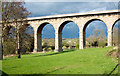
Arches of Newton Cap Viaduct
Newton Cap Viaduct once carried a rail route but in the 1990's it was adapted to road use meaning that traffic could avoid crossing the old Newton Cap Bridge.
Image: © Trevor Littlewood
Taken: 10 Apr 2017
0.04 miles
8
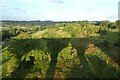
Shadows of Newton Cap Viaduct
Crossing over the River Wear, this viaduct once carried the Durham to Bishop Auckland Railway Line.
Image: © DS Pugh
Taken: 9 Sep 2023
0.04 miles
9
Newton Cap Viaduct : Rail to Road Conversion
Built in 1857 as a railway viaduct, closed 1968, re-opened to carry the A687, 1995. The 15th century, Skirlaw Bridge, built by Walter de Skirlaw of Durham 1388-1406. It has two arches: one a pointed one 91ft across and a rounded one 101ft wide crossing the River Wear, (bottom right). On the western end is a stone inscribed "Edward Palfreys Leap 1744".
Image: © Hugh Mortimer
Taken: 21 Jan 2007
0.05 miles
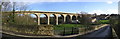
10
From bridge to viaduct
The view from Newton Cap bridge to the viaduct of the same name. The 11 arch viaduct was built for rail traffic in 1857, but after the demise of the railway it became a route for motor vehicles in 1995, thus avoiding the very narrow medieval bridge upstream.
Image: © Gordon Hatton
Taken: 13 Mar 2016
0.05 miles