IMAGES TAKEN NEAR TO
Raby Moor, BISHOP AUCKLAND, DL13 5HG
Introduction
This page details the photographs taken nearby to Raby Moor, DL13 5HG by members of the Geograph project.
The Geograph project started in 2005 with the aim of publishing, organising and preserving representative images for every square kilometre of Great Britain, Ireland and the Isle of Man.

There are currently over 7.5m images from over14,400 individuals and you can help contribute to the project by visiting https://www.geograph.org.uk
Image Map
Images are licensed for reuse under creativecommons.org/licenses/by-sa/2.0
Notes
- Clicking on the map will re-center to the selected point.
- The higher the marker number, the further away the image location is from the centre of the postcode.
Image Listing (15 Images Found)
Images are licensed for reuse under creativecommons.org/licenses/by-sa/2.0
Image
Details
Distance
2
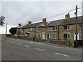
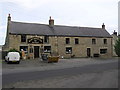
Burnt Houses
Although the name and evidence of a few dwellings appear on the first edition OS map of 1856, this row of cottages look later than that. Burnt Houses is no more than a hamlet along the road that follows the northern edge of the Raby Castle estate, but why were they built here? There's no evidence of coal mining in the immediate vicinity, and they don't look much like estate workers houses.
Image: © Gordon Hatton
Taken: 19 Aug 2023
0.01 miles
3
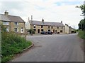
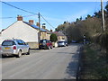
Road junction at Burnt Houses
Junction of Scotland Lane and Burnt Houses Lane. The left-hand house in the centre was formerly The Raby Moor Inn, now sadly closed and converted into a private house Image
Image: © Andrew Curtis
Taken: 21 Aug 2015
0.01 miles
4
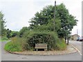
Stone bench, Burn Houses
The carved stone bench Image is on corner of Scotland Lane (left) and Burnt Houses Lane (right).
Image: © Andrew Curtis
Taken: 21 Aug 2015
0.02 miles
5
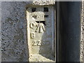
Ordnance Survey Flush Bracket 2230
This can be found on the track-side wall of a house at Burnt Houses. The benchmark height is recorded as 242.654 metres above sea level.
For more detail see : http://www.bench-marks.org.uk/bm891
Image: © Peter Wood
Taken: 25 Mar 2017
0.02 miles
6

Scotland Lane joining Burnt Houses Lane
Image: © Peter Robinson
Taken: 15 Jul 2012
0.02 miles
8
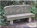
Carved Stone Seat : Burnt Houses
Opposite the Raby Moor Inn, on the corner of Scotland Lane.
Image: © Hugh Mortimer
Taken: 5 Nov 2006
0.03 miles
9
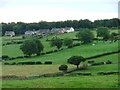
Burnt Houses
Viewed across the valley from Cockfield.
Image: © Mick Garratt
Taken: 2 Oct 2005
0.04 miles
10
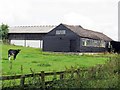
Farm near Burnt Houses
The map names the farm as Rise Slowly, possibly after Mount Slowly on the main road close to the north. It was formerly Burnt Houses Lodge.
Image: © Andrew Curtis
Taken: 21 Aug 2015
0.11 miles